
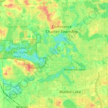
Commerce Charter Township topographic map
Interactive map
Click on the map to display elevation.
About this map
Name: Commerce Charter Township topographic map, elevation, terrain.
Average elevation: 286 m
Minimum elevation: 268 m
Maximum elevation: 310 m
Other topographic maps
Click on a map to view its topography, its elevation and its terrain.
Andersonville
United States > Michigan > Oakland County
Andersonville, Springfield Charter Township, Oakland County, Michigan, 48350, United States
Average elevation: 314 m
Pleasant Ridge
United States > Michigan > Oakland County
Pleasant Ridge, Oakland County, Michigan, 48069, United States
Average elevation: 201 m
Oxford Charter Township
United States > Michigan > Oakland County
Oxford Charter Township, Oakland County, Michigan, 48371, United States
Average elevation: 325 m
White Lake
United States > Michigan > Oakland County > White Lake Charter Township
White Lake, White Lake Charter Township, Oakland County, Michigan, United States
Average elevation: 314 m
Waterford Township
United States > Michigan > Oakland County
Waterford Township, Oakland County, Michigan, United States
Average elevation: 294 m
Brandon Charter Township
United States > Michigan > Oakland County
Brandon Charter Township, Oakland County, Michigan, 48462, United States
Average elevation: 318 m
Seven Harbors
United States > Michigan > Oakland County > Highland Charter Township
Seven Harbors, Highland Charter Township, Oakland County, Michigan, 48356, United States
Average elevation: 314 m
Madison Heights
United States > Michigan > Oakland County
Madison Heights, Oakland County, Michigan, 48071, United States
Average elevation: 196 m
Royal Oak
United States > Michigan > Oakland County
Royal Oak, Oakland County, Michigan, United States
Average elevation: 203 m
Hazel Park
United States > Michigan > Oakland County
Hazel Park, Oakland County, Michigan, 48030, United States
Average elevation: 195 m
Wixom
United States > Michigan > Oakland County
Wixom, Oakland County, Michigan, United States
Average elevation: 288 m
Milford Charter Township
United States > Michigan > Oakland County
Milford Charter Township, Oakland County, Michigan, United States
Average elevation: 296 m
West Bloomfield Township
United States > Michigan > Oakland County
West Bloomfield Township, Oakland County, Michigan, United States
Average elevation: 286 m
New Hudson
United States > Michigan > Oakland County > Lyon Charter Township
New Hudson, Lyon Charter Township, Oakland County, Michigan, 48165, United States
Average elevation: 290 m
Clawson
United States > Michigan > Oakland County
Clawson, Oakland County, Michigan, 48017, United States
Average elevation: 206 m
Sylvan Lake
United States > Michigan > Oakland County
Sylvan Lake, Oakland County, Michigan, 48320, United States
Average elevation: 287 m
Bloomfield Hills
United States > Michigan > Oakland County
Bloomfield Hills, Oakland County, Michigan, 48304, United States
Average elevation: 261 m
Seven Lakes State Park
United States > Michigan > Oakland County
Seven Lakes State Park, 14390, Oakland County, Michigan, 48442, United States
Average elevation: 281 m
Auburn Hills
United States > Michigan > Oakland County
Auburn Hills, Oakland County, Michigan, 48326, United States
Average elevation: 284 m
Farmington Hills
United States > Michigan > Oakland County
Farmington Hills, Oakland County, Michigan, United States
Average elevation: 246 m
Waterbury Lake
United States > Michigan > Oakland County > Highland Charter Township
Waterbury Lake, Highland Charter Township, Oakland County, Michigan, United States
Average elevation: 308 m
Hickory Ridge
United States > Michigan > Oakland County > Highland Charter Township
Hickory Ridge, Highland Charter Township, Oakland County, Michigan, 48357, United States
Average elevation: 326 m
Veterans Park
United States > Michigan > Oakland County > Highland Charter Township
Veterans Park, Highland Charter Township, Oakland County, Michigan, 48357, United States
Average elevation: 310 m
Round Lake
United States > Michigan > Oakland County > Orion Charter Township
Round Lake, Orion Charter Township, Oakland County, Michigan, United States
Average elevation: 303 m
White Lake Charter Township
United States > Michigan > Oakland County
White Lake Charter Township, Oakland County, Michigan, 48383, United States
Average elevation: 302 m
Mt. Sheldon
United States > Michigan > Oakland County
Mt. Sheldon, Oakland County, Michigan, United States
Average elevation: 257 m
Southfield
United States > Michigan > Oakland County
Southfield, Oakland County, Michigan, United States
Average elevation: 210 m
Holly
United States > Michigan > Oakland County
Holly, Oakland County, Michigan, 48442, United States
Average elevation: 285 m
Independence Charter Township
United States > Michigan > Oakland County
Independence Charter Township, Oakland County, Michigan, United States
Average elevation: 318 m
Orion Charter Township
United States > Michigan > Oakland County
Orion Charter Township, Oakland County, Michigan, United States
Average elevation: 306 m
Rochester Hills
United States > Michigan > Oakland County
Rochester Hills, Oakland County, Michigan, United States
Average elevation: 250 m
Lake Orion Heights
United States > Michigan > Oakland County
Lake Orion Heights, Oakland County, Michigan, 48361, United States
Average elevation: 304 m
Bingham Farms
United States > Michigan > Oakland County
Bingham Farms, Southfield Township, Oakland County, Michigan, United States
Average elevation: 222 m
Ferndale
United States > Michigan > Oakland County
Ferndale, Oakland County, Michigan, 48220, United States
Average elevation: 200 m
Novi
United States > Michigan > Oakland County
Novi, Oakland County, Michigan, United States
Average elevation: 280 m
Davisburg
United States > Michigan > Oakland County > Springfield Charter Township
Davisburg, Springfield Charter Township, Oakland County, Michigan, 48350, United States
Average elevation: 309 m
Waterford
United States > Michigan > Oakland County > Waterford Township
Waterford, Waterford Township, Oakland County, Michigan, 48346, United States
Average elevation: 300 m
Highland State Recreation Area
United States > Michigan > Oakland County > Highland
Highland State Recreation Area, Highland, Oakland County, Michigan, United States
Average elevation: 302 m
Lyon Charter Township
United States > Michigan > Oakland County
Lyon Charter Township, Oakland County, Michigan, 48165, United States
Average elevation: 291 m
Pontiac
United States > Michigan > Oakland County
Pontiac, Oakland County, Michigan, United States
Average elevation: 290 m
Orchard Lake
United States > Michigan > Oakland County
Orchard Lake, Oakland County, Michigan, United States
Average elevation: 287 m
Lake Orion
United States > Michigan > Oakland County
Lake Orion, Oakland County, Michigan, 48362, United States
Average elevation: 303 m
Bloomfield
United States > Michigan > Oakland County > Birmingham
Bloomfield, Birmingham, Oakland County, Michigan, 35075, United States
Average elevation: 231 m
Birmingham
United States > Michigan > Oakland County
Birmingham, Oakland County, Michigan, United States
Average elevation: 234 m
Leonard
United States > Michigan > Oakland County > Leonard
Leonard, Oakland County, Michigan, United States
Average elevation: 306 m
Bald Mountain
United States > Michigan > Oakland County > Auburn Hills
Bald Mountain, Auburn Hills, Oakland County, Michigan, 48326, United States
Average elevation: 313 m
Franklin
United States > Michigan > Oakland County
Franklin, Southfield Township, Oakland County, Michigan, United States
Average elevation: 241 m
Troy
United States > Michigan > Oakland County
Troy, Oakland County, Michigan, United States
Average elevation: 221 m
Clarkston
United States > Michigan > Oakland County
Clarkston, Oakland County, Michigan, United States
Average elevation: 308 m
White Lake Charter Township
United States > Michigan > Oakland County
White Lake Charter Township, Oakland County, Michigan, United States
Average elevation: 303 m