
Quebec topographic map
Interactive map
Click on the map to display elevation.
About this map
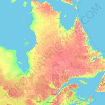
Name: Quebec topographic map, elevation, terrain.
Location: Quebec, Canada (44.99137 -79.76287 62.58250 -57.10749)
Average elevation: 195 m
Minimum elevation: -2 m
Maximum elevation: 1,383 m
Quebec's topography is very different from one region to another due to the varying composition of the ground, the climate, and the proximity to water. More than 95% of Quebec's territory, including the Labrador Peninsula, lies within the Canadian Shield. It is generally a quite flat and exposed mountainous terrain interspersed with higher points such as the Laurentian Mountains in southern Quebec, the Otish Mountains in central Quebec and the Torngat Mountains near Ungava Bay. While low and medium altitude peaks extend from western Quebec to the far north, high altitudes mountains emerge in the Capitale-Nationale region to the extreme east. Quebec's highest point at 1,652 metres (5,420 ft) is Mont d'Iberville, known in English as Mount Caubvick. In the Labrador Peninsula portion of the Shield, the far northern region of Nunavik includes the Ungava Peninsula and consists of flat Arctic tundra inhabited mostly by the Inuit. Further south is the Eastern Canadian Shield taiga ecoregion and the Central Canadian Shield forests. The Appalachian region has a narrow strip of ancient mountains along the southeastern border of Quebec.
Other topographic maps
Click on a map to view its topography, its elevation and its terrain.
Charlottetown
Canada > Prince Edward Island > Queens County
Charlottetown, Queens County, Prince Edward Island, Canada
Average elevation: 19 m
Halifax
Canada > Nova Scotia > Halifax County
Halifax, Halifax Regional Municipality, Halifax County, Nova Scotia, Canada
Average elevation: 46 m
Root River
Canada > Northwest Territories
Root River, Northwest Territories, Canada
Average elevation: 786 m
Metro Vancouver Regional District
Metro Vancouver Regional District, British Columbia, Canada
Average elevation: 343 m
Quebec
Canada > Quebec > Urban agglomeration of Québec
Quebec, Urban agglomeration of Québec, Capitale-Nationale, Quebec, Canada
Average elevation: 117 m
Uxbridge
Canada > Ontario > Durham Region
Uxbridge, Durham Region, Golden Horseshoe, Ontario, Canada
Average elevation: 284 m
Val-d'Or
Canada > Quebec > La Vallée-de-l'Or
Val-d'Or, La Vallée-de-l'Or, Abitibi-Témiscamingue, Quebec, Canada
Average elevation: 331 m
Fairmont Hot Springs
Canada > British Columbia > Regional District of East Kootenay > Area F (Columbia Lake/Windermere Lake)
Fairmont Hot Springs, Area F (Columbia Lake/Windermere Lake), Regional District of East Kootenay, British Columbia, V0B 1L0, Canada
Average elevation: 920 m
Vancouver Island
Vancouver Island, British Columbia, Canada
Average elevation: 411 m
Area I (Blue Sky Country)
Canada > British Columbia > Thompson-Nicola Regional District
Area I (Blue Sky Country), Thompson-Nicola Regional District, British Columbia, Canada
Average elevation: 1,311 m
Beach Mountain
Canada > British Columbia > Squamish-Lillooet Regional District > Area C (Pemberton Valley/Mount Currie/D'Arcy)
Beach Mountain, Area C (Pemberton Valley/Mount Currie/D'Arcy), Squamish-Lillooet Regional District, British Columbia, Canada
Average elevation: 2,063 m
Town of Kensington
Canada > Prince Edward Island > Prince County
Town of Kensington, Prince County, Prince Edward Island, Canada
Average elevation: 36 m
Calm Lake
Canada > Ontario > Rainy River District > Unorganized Rainy River
Calm Lake, Unorganized Rainy River, Rainy River District, Northwestern Ontario, Ontario, Canada
Average elevation: 391 m
Ruby Creek
Canada > British Columbia > Fraser Valley Regional District > Skawahlook > Ruby Creek
Ruby Creek, Skawahlook, Fraser Valley Regional District, British Columbia, Canada
Average elevation: 169 m
Gibson Island
Canada > British Columbia > North Coast Regional District > Area C (South Skeena)
Gibson Island, Area C (South Skeena), North Coast Regional District, British Columbia, Canada
Average elevation: 8 m
The Channel
Canada > Nova Scotia > Yarmouth County > Tusket Islands
The Channel, Tusket Islands, Argyle Municipal District, Yarmouth County, Nova Scotia, Canada
Average elevation: 3 m
Aberdeen
Canada > Saskatchewan > Division No. 15
Aberdeen, Division No. 15, Saskatchewan, S0K 0A0, Canada
Average elevation: 518 m
Oak Island
Canada > Nova Scotia > Avonport
Oak Island, Avonport, Municipality of the County of Kings, Kings County, Nova Scotia, B0P 1M0, Canada
Average elevation: 83 m
Tsawwassen First Nation
Canada > British Columbia > Metro Vancouver Regional District
Tsawwassen First Nation, Tsawwassen, Metro Vancouver Regional District, British Columbia, Canada
Average elevation: 5 m
Brooks
Canada > Alberta > City of Brooks
Brooks, City of Brooks, Alberta, Canada
Average elevation: 758 m
Area D (Lardeau Valley/Duncan Lake)
Canada > British Columbia > Regional District of Central Kootenay
Area D (Lardeau Valley/Duncan Lake), Regional District of Central Kootenay, British Columbia, Canada
Average elevation: 1,660 m
Nejanilini Lake
Canada > Manitoba > Division No. 23 > Unorganized Division No. 23
Nejanilini Lake, Unorganized Division No. 23, Division No. 23, Manitoba, Canada
Average elevation: 280 m
Alberton
Canada > Prince Edward Island > Town of Alberton
Alberton, Town of Alberton, Prince County, Prince Edward Island, C0B 1B0, Canada
Average elevation: 7 m
Balmoral
Canada > Nova Scotia > Municipality of the County of Richmond
Balmoral, Grande Anse, Municipality of the County of Richmond, Richmond County, Nova Scotia, B0E 3K0, Canada
Average elevation: 55 m
Vancouver
Canada > British Columbia > Metro Vancouver Regional District
Vancouver, Metro Vancouver Regional District, British Columbia, Canada
Average elevation: 34 m
Tumbler Ridge
Canada > British Columbia > Peace River Regional District
Tumbler Ridge, Peace River Regional District, British Columbia, V0C 2W0, Canada
Average elevation: 1,153 m
Niagara Falls
Canada > Ontario > Niagara Region
Niagara Falls, Niagara Region, Golden Horseshoe, Ontario, Canada
Average elevation: 179 m
King Edward Park
Canada > Alberta > Division No. 11 > Edmonton
King Edward Park, Mill Creek South, Edmonton, Division No. 11, Alberta, Canada
Average elevation: 671 m
Flat Rock
Canada > Nova Scotia > Municipality of the County of Richmond > Grand River
Flat Rock, Grand River, Municipality of the County of Richmond, Richmond County, Nova Scotia, Canada
Average elevation: 5 m
Garden River No. 490
Canada > Saskatchewan > Division No. 15
Garden River No. 490, Division No. 15, Saskatchewan, Canada
Average elevation: 467 m
Brigham
Canada > Quebec > Brome-Missisquoi
Brigham, Brome-Missisquoi, Estrie, Quebec, J2K 4V6, Canada
Average elevation: 96 m
Yellowknife
Canada > Northwest Territories > North Slave Region
Yellowknife, North Slave Region, Northwest Territories, Canada
Average elevation: 185 m
Nobleton
Canada > Ontario > York Region > King
Nobleton, King, York Region, Golden Horseshoe, Ontario, L0G 1N0, Canada
Average elevation: 264 m
Summerland
Canada > British Columbia > Regional District of Okanagan-Similkameen
Summerland, Regional District of Okanagan-Similkameen, British Columbia, Canada
Average elevation: 696 m
Mount Sylvia
Canada > British Columbia > Northern Rockies Regional Municipality
Mount Sylvia, Northern Rockies Regional Municipality, British Columbia, Canada
Average elevation: 2,288 m
York
Canada > Ontario > Haldimand County
York, Haldimand County, Ontario, Canada
Average elevation: 197 m
The Blue Mountains
Canada > Ontario > Grey County
The Blue Mountains, Grey County, Ontario, N0H 2P0, Canada
Average elevation: 265 m
Oakland Lake
Canada > Nova Scotia > Digby County
Oakland Lake, Digby Municipal District, Digby County, Nova Scotia, Canada
Average elevation: 155 m
Cookville
Canada > Nova Scotia > Lunenburg County
Cookville, Municipality of the District of Lunenburg, Lunenburg County, Nova Scotia, Canada
Average elevation: 66 m
Caribou River
Canada > Nova Scotia > Municipality of Pictou County
Caribou River, Municipality of Pictou County, Pictou County, Nova Scotia, Canada
Average elevation: 12 m
Town of Mayerthorpe
Canada > Alberta > Division No. 13
Town of Mayerthorpe, Division No. 13, Alberta, T0E 1N0, Canada
Average elevation: 711 m
Sauble Beach
Canada > Ontario > Bruce County
Sauble Beach, South Bruce Peninsula, Bruce County, Ontario, N0H 2G0, Canada
Average elevation: 188 m