
Puerto Galera topographic map
Interactive map
Click on the map to display elevation.
About this map
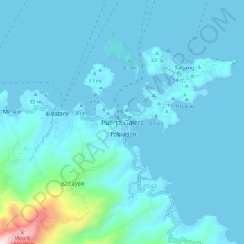
Name: Puerto Galera topographic map, elevation, terrain.
Location: Puerto Galera, Oriental Mindoro, Mimaropa, Philippines (13.46183 120.91418 13.54183 120.99418)
Average elevation: 81 m
Minimum elevation: -1 m
Maximum elevation: 996 m
Other topographic maps
Click on a map to view its topography, its elevation and its terrain.
Santo Niño
Philippines > Oriental Mindoro > Puerto Galera
Santo Niño, Puerto Galera, Oriental Mindoro, Mimaropa, Philippines
Average elevation: 44 m