
Make a donation
Melbourne topographic map
Click on the map to display elevation.
Make a donation
Melbourne
Melbourne is also prone to isolated convective showers forming when a cold pool crosses the state, especially if there is considerable daytime heating. These showers are often heavy and can include hail, squalls, and significant drops in temperature, but they often pass through very quickly with a rapid clearing trend to sunny and relatively calm weather and the temperature rising back to what it was before the shower. This can occur in the space of minutes and can be repeated many times a day, giving Melbourne a reputation for having "four seasons in one day", a phrase that is part of local popular culture. The lowest temperature on record is −2.8 °C (27.0 °F), on 21 July 1869. The highest temperature recorded in Melbourne city was 46.4 °C (115.5 °F), on 7 February 2009. While snow is occasionally seen at higher elevations in the outskirts of the city, it has not been recorded in the Central Business District since 1986.
Make a donation
About this map
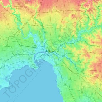
Name: Melbourne topographic map, elevation, terrain.
Location: Melbourne, City of Melbourne, Victoria, Australia (-37.97425 144.80317 -37.65425 145.12317)
Average elevation: 49 m
Minimum elevation: -5 m
Maximum elevation: 191 m
Make a donation
Other topographic maps
Click on a map to view its topography, its elevation and its terrain.
City of Melbourne
Melbourne's topography is characterized by a diverse landscape that transitions from flat coastal plains to rolling hills and mountainous regions. The city is situated at the northern end of Port Phillip Bay, where the terrain is predominantly flat, facilitating urban development. As one moves eastward, the…
Average elevation: 18 m
Melbourne
Melbourne is also prone to isolated convective showers forming when a cold pool crosses the state, especially if there is considerable daytime heating. These showers are often heavy and can include hail, squalls, and significant drops in temperature, but they often pass through very quickly with a rapid…
Average elevation: 185 m
Make a donation
Make a donation
Make a donation
Make a donation
Make a donation
Port Phillip
Port Phillip's mostly flat topography and moderate waves make perfect conditions for recreational swimming, kitesurfing, windsurfing, sailing, boating, snorkeling, scuba diving, stand up paddle boarding (SUP) and other sports.
Average elevation: 18 m
Make a donation
Make a donation
Western Port
Formerly a major river drainage system, it was inundated together with Port Phillip by the rising sea in the Holocene period; the Western Port sunkland now forms an extensive tidal bay. The waters of Western Port cover an area of 680 km² of which 270 km² are exposed as mud flats at low tide. The topography…
Average elevation: 35 m
Make a donation
Make a donation
Make a donation
Make a donation
Albert Park
Heritage Victoria notes that Albert Park's St Vincent Gardens "is historically important as the premier 'square' development in Victoria based on similar models in London. It is significant as the largest development of its type in Victoria and for its unusual development as gardens rather than the more usual…
Average elevation: 6 m
Make a donation
Make a donation
Castlemaine
The Castlemaine goldfields' legendary prosperity raised expectations of Castlemaine becoming Victoria's second city. That is reflected in imposing buildings erected in the town's first few years. Though the rich alluvial diggings were largely exhausted within 15–20 years causing the town's population to…
Average elevation: 319 m
Make a donation
Templestowe
Australia > Victoria > Melbourne
Gentle, rolling hills extend from east of the Yarra River flood plains, along Templestowe Road (towards the Eastern Freeway) for seven km (4.3 miles), to the north-east. The altitude of the plain above sea level is 50 m, and the topography is subdued and mostly flat; the hills are just below 60 m, the slopes…
Average elevation: 66 m
Make a donation
Make a donation
Make a donation
Dandenong Ranges National Park - Ferntree Gully
Australia > Victoria > Montrose
The topography consists of a series of ridges dissected by deeply cut streams. Sheltered gullies in the south of the range are home to temperate rain forest, fern gullies and Mountain Ash forest Eucalyptus regnans, whereas the drier ridges and exposed northern slopes are covered by dry sclerophyll forest of…
Average elevation: 345 m
Frankston
Olivers Hill is the most prominent elevation in Frankston which rises to 55 metres above sea level (180 feet) at its highest point in the suburb. Its origins date to approximately 415 to 360 million years ago. Its base is Mount Eliza Granite dating from the Devonian period, which was covered in lava tuffs in…
Average elevation: 40 m
Make a donation
Grampians National Park
Mount William is known within the gliding community for the "Grampians Wave", a weather phenomenon that sometimes enables glider pilots to reach extreme altitudes of the order of 28,000 ft (8,500 m). This predominantly occurs during the months of May, June, September and October when strong westerly winds flow…
Average elevation: 262 m
Make a donation
Make a donation
Make a donation
Make a donation
Make a donation
Make a donation
Make a donation