
Wyoming topographic map
Interactive map
Click on the map to display elevation.
About this map
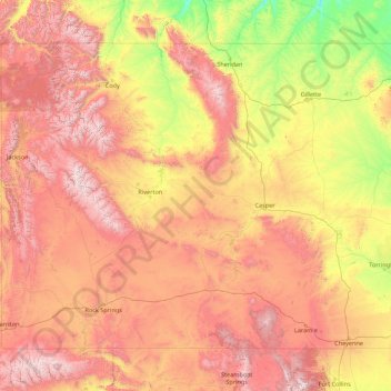
Name: Wyoming topographic map, elevation, terrain.
Location: Wyoming, United States (40.99482 -111.05527 45.00583 -104.05239)
Average elevation: 1,938 m
Minimum elevation: 916 m
Maximum elevation: 4,047 m
Wyoming's western half is covered mostly by the ranges and rangelands of the Rocky Mountains, while the eastern half of the state is high-elevation prairie called the High Plains. It is drier and windier than the rest of the country, being split between semi-arid and continental climates with greater temperature extremes. Almost half of the land in Wyoming is owned by the federal government, generally protected for public uses. The state ranks 6th by area and fifth by proportion of a state's land owned by the federal government. Federal lands include two national parks (Grand Teton and Yellowstone), two national recreation areas, two national monuments, several national forests, historic sites, fish hatcheries, and wildlife refuges.
Other topographic maps
Click on a map to view its topography, its elevation and its terrain.
Kingwood
United States > Texas > Harris County > Houston
Kingwood, Houston, Harris County, Texas, 77345, United States
Average elevation: 22 m
Houston
United States > Texas > Harris County
Houston, Harris County, Texas, United States
Average elevation: 25 m
Seattle
United States > Washington > King County
Seattle, King County, Washington, United States
Average elevation: 40 m
Austin
United States > Texas > Travis County
Austin, Travis County, Texas, United States
Average elevation: 216 m
San Francisco
San Francisco, California, United States
Average elevation: 63 m
Dallas
United States > Texas > Dallas County
Dallas, Dallas County, Texas, United States
Average elevation: 160 m
Reno
United States > Nevada > Washoe County
Reno, Washoe County, Nevada, United States
Average elevation: 1,650 m
Conroe
United States > Texas > Montgomery County
Conroe, Montgomery County, Texas, United States
Average elevation: 62 m
Pittsburgh
United States > Pennsylvania > Allegheny County
Pittsburgh, Allegheny County, Pennsylvania, United States
Average elevation: 303 m
Atlanta
United States > Georgia > Fulton County
Atlanta, Fulton County, Georgia, United States
Average elevation: 284 m
San Antonio
United States > Texas > Bexar County
San Antonio, Bexar County, Texas, United States
Average elevation: 247 m
San Diego
United States > California > San Diego County
San Diego, San Diego County, California, United States
Average elevation: 125 m
Salt Lake City
United States > Utah > Salt Lake County
Salt Lake City, Salt Lake County, Utah, United States
Average elevation: 1,592 m
Bend
United States > Oregon > Deschutes County
Bend, Deschutes County, Oregon, United States
Average elevation: 1,121 m
Phoenix
United States > Arizona > Maricopa County
Phoenix, Maricopa County, Arizona, United States
Average elevation: 481 m
Denver
United States > Colorado > Denver County > Denver
Denver, Denver County, Colorado, United States
Average elevation: 1,684 m
Las Vegas
United States > Nevada > Clark County
Las Vegas, Clark County, Nevada, United States
Average elevation: 756 m
Philadelphia
United States > Pennsylvania > Philadelphia County
Philadelphia, Pennsylvania, United States
Average elevation: 44 m
Portland
United States > Oregon > Multnomah County
Portland, Multnomah County, Oregon, United States
Average elevation: 77 m
Chicago
United States > Illinois > Cook County
Chicago, Cook County, Illinois, United States
Average elevation: 182 m
Saint Petersburg
United States > Florida > Pinellas County
Saint Petersburg, Pinellas County, Florida, United States
Average elevation: 4 m
Albuquerque
United States > New Mexico > Bernalillo County
Albuquerque, Bernalillo County, New Mexico, United States
Average elevation: 1,688 m
Knoxville
United States > Tennessee > Knox County
Knoxville, Knox County, East Tennessee, Tennessee, United States
Average elevation: 307 m
Cypress
United States > Texas > Harris County
Cypress, Harris County, Texas, 77433, United States
Average elevation: 46 m
El Paso
United States > Texas > El Paso County
El Paso, El Paso County, Texas, United States
Average elevation: 1,237 m
Greenville
United States > South Carolina > Greenville County
Greenville, Greenville County, South Carolina, United States
Average elevation: 290 m
Lake Tahoe
United States > California > Placer County
Lake Tahoe, Placer County, California, United States
Average elevation: 2,077 m
Boston
United States > Massachusetts > Suffolk County
Boston, Suffolk County, Massachusetts, United States
Average elevation: 25 m
Kansas City
United States > Missouri > Jackson County
Kansas City, Jackson County, Missouri, United States
Average elevation: 277 m
Nashville-Davidson
United States > Tennessee > Davidson County
Nashville-Davidson, Davidson County, Middle Tennessee, Tennessee, United States
Average elevation: 184 m
Chattanooga
United States > Tennessee > Hamilton County
Chattanooga, Hamilton County, East Tennessee, Tennessee, United States
Average elevation: 331 m