
Bow Pass topographic map
Interactive map
Click on the map to display elevation.
About this map
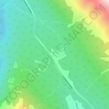
Name: Bow Pass topographic map, elevation, terrain.
Location: Bow Pass, Observation Peak Route, Alberta, Canada (51.72045 -116.49302 51.72055 -116.49292)
Average elevation: 2,119 m
Minimum elevation: 1,841 m
Maximum elevation: 2,811 m
Other topographic maps
Click on a map to view its topography, its elevation and its terrain.
Emerald Lake
Canada > Alberta > Division No. 15
Emerald Lake, Municipality of Crowsnest Pass, Division No. 15, Alberta, Canada
Average elevation: 1,561 m
Municipality of Jasper
Municipality of Jasper, Alberta, T0E 1E0, Canada
Average elevation: 1,798 m
Jasper National Park
Jasper National Park, Alberta, T0E 1E0, Canada
Average elevation: 1,782 m
Medicine Hat
Canada > Alberta > Medicine Hat
Medicine Hat, City of Medicine Hat, Alberta, T1A 8E6, Canada
Average elevation: 744 m
Edmonton
Canada > Alberta > Division No. 11
Edmonton, Division No. 11, Alberta, Canada
Average elevation: 689 m
Fort Saskatchewan
Canada > Alberta > Fort Saskatchewan
Fort Saskatchewan, Alberta, T8L 1Y8, Canada
Average elevation: 662 m
Mount Black Prince
Mount Black Prince, Kananaskis Improvement District, Alberta, Canada
Average elevation: 2,276 m
Waterton Park
Canada > Alberta > Waterton Park
Waterton Park, Alberta, Canada
Average elevation: 1,471 m