
Páramo topographic map
Interactive map
Click on the map to display elevation.
About this map
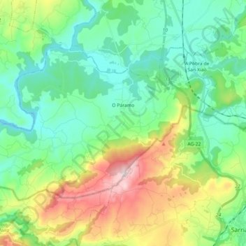
Name: Páramo topographic map, elevation, terrain.
Location: Páramo, Sarria, Lugo, Galicia, España (42.79404 -7.60924 42.87614 -7.43123)
Average elevation: 485 m
Minimum elevation: 327 m
Maximum elevation: 870 m
Other topographic maps
Click on a map to view its topography, its elevation and its terrain.
Santo André
España > Galicia > Sarria > Páramo
Santo André, Santo André da Ribeira, Páramo, Sarria, Lugo, Galicia, 27362, España
Average elevation: 413 m