
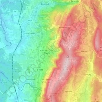
Les Trois Châteaux topographic map
Interactive map
Click on the map to display elevation.
About this map
Name: Les Trois Châteaux topographic map, elevation, terrain.
Average elevation: 372 m
Minimum elevation: 203 m
Maximum elevation: 616 m
Other topographic maps
Click on a map to view its topography, its elevation and its terrain.
Saint-Jean-d'Étreux
France > Bourgogne-Franche-Comté > Jura > Les Trois-Châteaux
Saint-Jean-d'Étreux, Les Trois-Châteaux, Lons-le-Saunier, Jura, Bourgogne-Franche-Comté, France métropolitaine, 39160, France
Average elevation: 417 m
L'Aubépin
France > Bourgogne-Franche-Comté > Jura > Les Trois-Châteaux
L'Aubépin, Les Trois-Châteaux, Lons-le-Saunier, Jura, Bourgogne-Franche-Comté, France métropolitaine, 39160, France
Average elevation: 481 m
Chazelles
France > Bourgogne-Franche-Comté > Jura > Les Trois-Châteaux
Chazelles, Les Trois-Châteaux, Lons-le-Saunier, Jura, Bourgogne-Franche-Comté, France métropolitaine, 39160, France
Average elevation: 269 m
Cessia
France > Bourgogne-Franche-Comté > Jura > Les Trois-Châteaux
Cessia, Saint-Jean-d'Étreux, Les Trois-Châteaux, Lons-le-Saunier, Jura, Bourgogne-Franche-Comté, France métropolitaine, 39160, France
Average elevation: 397 m
Nanc-lès-Saint-Amour
France > Bourgogne-Franche-Comté > Jura > Les Trois-Châteaux
Nanc-lès-Saint-Amour, Les Trois-Châteaux, Lons-le-Saunier, Jura, Bourgogne-Franche-Comté, France métropolitaine, 39160, France
Average elevation: 334 m