
Zinnik topographic map
Interactive map
Click on the map to display elevation.
About this map
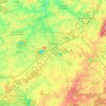
Name: Zinnik topographic map, elevation, terrain.
Location: Zinnik, Henegouwen, Wallonië, België (50.50036 3.95217 50.63361 4.13055)
Average elevation: 98 m
Minimum elevation: 35 m
Maximum elevation: 168 m
Other topographic maps
Click on a map to view its topography, its elevation and its terrain.
Ronquières
België > Henegouwen > Zinnik > 's-Gravenbrakel
Ronquières, 's-Gravenbrakel, Zinnik, Henegouwen, Wallonië, 7090, België
Average elevation: 93 m
's-Gravenbrakel
België > Henegouwen > Zinnik
's-Gravenbrakel, Zinnik, Henegouwen, Wallonië, 7090, België
Average elevation: 89 m