
La Masure topographic map
Interactive map
Click on the map to display elevation.
About this map
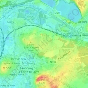
Name: La Masure topographic map, elevation, terrain.
Location: La Masure, Mons, Hainaut, Wallonie, 7000, Belgique (50.44585 3.95856 50.48585 3.99856)
Average elevation: 46 m
Minimum elevation: 28 m
Maximum elevation: 87 m
Other topographic maps
Click on a map to view its topography, its elevation and its terrain.
Villers-Saint-Ghislain
Belgique > Hainaut > Mons > Mons
Villers-Saint-Ghislain, Mons, Hainaut, Wallonie, 7031, Belgique
Average elevation: 74 m
Terril de l'Héribus
Belgique > Hainaut > Mons > Mons
Terril de l'Héribus, Mons, Hainaut, Wallonie, 7024, Belgique
Average elevation: 44 m
Harmignies
Belgique > Hainaut > Mons > Mons > Harmignies
Harmignies, Mons, Hainaut, Wallonie, 7022, Belgique
Average elevation: 65 m