
Montacute topographic map
Interactive map
Click on the map to display elevation.
About this map
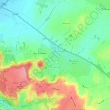
Name: Montacute topographic map, elevation, terrain.
Location: Montacute, South Somerset, Somerset, England, United Kingdom (50.93618 -2.74431 50.96964 -2.69212)
Average elevation: 66 m
Minimum elevation: 21 m
Maximum elevation: 141 m
Other topographic maps
Click on a map to view its topography, its elevation and its terrain.
Wambrook
United Kingdom > England > Somerset > South Somerset > Wambrook
Wambrook, South Somerset, Somerset, South West England, England, United Kingdom
Average elevation: 184 m