
Marietta topographic map
Interactive map
Click on the map to display elevation.
About this map
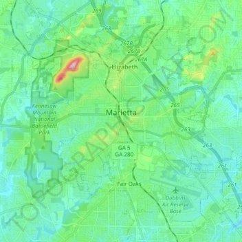
Name: Marietta topographic map, elevation, terrain.
Location: Marietta, Cobb County, Georgia, United States (33.89559 -84.61681 34.00117 -84.46794)
Average elevation: 323 m
Minimum elevation: 274 m
Maximum elevation: 532 m
Other topographic maps
Click on a map to view its topography, its elevation and its terrain.
Vinings
United States > Georgia > Cobb County
Vinings, Cobb County, Georgia, 30339, United States
Average elevation: 281 m
Kennesaw
United States > Georgia > Cobb County
Kennesaw, Cobb County, Georgia, 30144, United States
Average elevation: 317 m
Acworth
United States > Georgia > Cobb County
Acworth, Cobb County, Georgia, United States
Average elevation: 281 m
North Georgia Fairgrounds Lake Dam
United States > Georgia > Cobb County
North Georgia Fairgrounds Lake Dam, Cobb County, Georgia, 30008, United States
Average elevation: 313 m
Lost Mountain Park
United States > Georgia > Cobb County
Lost Mountain Park, Cobb County, Georgia, United States
Average elevation: 343 m
Austell
United States > Georgia > Cobb County
Austell, Cobb County, Georgia, United States
Average elevation: 289 m
Clarkdale
United States > Georgia > Cobb County
Clarkdale, Cobb County, Georgia, 30111, United States
Average elevation: 281 m
Smyrna
United States > Georgia > Cobb County
Smyrna, Cobb County, Georgia, United States
Average elevation: 289 m
Powder Springs
United States > Georgia > Cobb County
Powder Springs, Cobb County, Georgia, United States
Average elevation: 291 m
Fair Oaks
United States > Georgia > Cobb County
Fair Oaks, Cobb County, Georgia, United States
Average elevation: 329 m
Kennesaw Mountain
United States > Georgia > Cobb County
Kennesaw Mountain, Cobb County, Georgia, 30090, United States
Average elevation: 360 m
Mableton
United States > Georgia > Cobb County
Mableton, Cobb County, Georgia, 30126, United States
Average elevation: 298 m
Austell
United States > Georgia > Cobb County > Austell
Austell, Cobb County, Georgia, 30001, United States
Average elevation: 283 m
Kennesaw
United States > Georgia > Cobb County > Kennesaw
Kennesaw, Cobb County, Georgia, 30144, United States
Average elevation: 318 m
Viking Quarry Lake
United States > Georgia > Cobb County
Viking Quarry Lake, Cobb County, Georgia, United States
Average elevation: 303 m
Lost Mountain
United States > Georgia > Cobb County
Lost Mountain, Cobb County, Georgia, United States
Average elevation: 340 m
Marietta
United States > Georgia > Cobb County > Marietta
Marietta, Cobb County, Georgia, 30090, United States
Average elevation: 302 m
Acworth
United States > Georgia > Cobb County > Acworth
Acworth, Cobb County, Georgia, 30101, United States
Average elevation: 280 m
Sweetwater Creek
United States > Georgia > Cobb County > Douglasville
Sweetwater Creek, Douglasville, Cobb County, Georgia, 30122, United States
Average elevation: 287 m