
Village of Oriskany topographic map
Interactive map
Click on the map to display elevation.
About this map
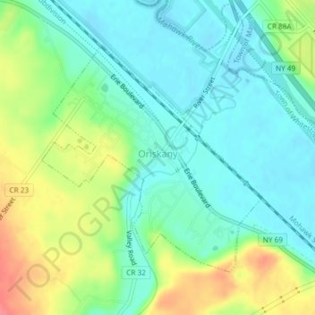
Name: Village of Oriskany topographic map, elevation, terrain.
Average elevation: 145 m
Minimum elevation: 122 m
Maximum elevation: 189 m
Other topographic maps
Click on a map to view its topography, its elevation and its terrain.
Village of Remsen
United States > New York > Oneida County > Town of Remsen
Village of Remsen, Town of Remsen, Oneida County, New York, United States
Average elevation: 375 m
Town of Sangerfield
United States > New York > Oneida County
Town of Sangerfield, Oneida County, New York, United States
Average elevation: 436 m
Brothertown
United States > New York > Oneida County > Town of Marshall
Brothertown, Town of Marshall, Oneida County, New York, 13328, United States
Average elevation: 340 m
Town of Remsen
United States > New York > Oneida County
Town of Remsen, Oneida County, New York, United States
Average elevation: 391 m
Town of New Hartford
United States > New York > Oneida County
Town of New Hartford, Oneida County, New York, United States
Average elevation: 240 m
Verona Beach
United States > New York > Oneida County > Town of Verona
Verona Beach, Town of Verona, Oneida County, New York, 13162, United States
Average elevation: 114 m
Sauquoit
United States > New York > Oneida County > Town of Paris
Sauquoit, Town of Paris, Oneida County, New York, 13456, United States
Average elevation: 309 m
Town of Boonville
United States > New York > Oneida County
Town of Boonville, Oneida County, New York, 13309, United States
Average elevation: 394 m
Village of New York Mills
United States > New York > Oneida County
Village of New York Mills, Town of Whitestown, Oneida County, New York, 13417, United States
Average elevation: 154 m
Town of Camden
United States > New York > Oneida County
Town of Camden, Oneida County, New York, 13316, United States
Average elevation: 214 m
Village of Clayville
United States > New York > Oneida County
Village of Clayville, Town of Paris, Oneida County, New York, United States
Average elevation: 361 m
Otter Lake
United States > New York > Oneida County > Town of Forestport
Otter Lake, Town of Forestport, Oneida County, New York, United States
Average elevation: 494 m
Town of Annsville
United States > New York > Oneida County
Town of Annsville, Oneida County, New York, 13471, United States
Average elevation: 273 m
Town of Lee
United States > New York > Oneida County
Town of Lee, Oneida County, New York, 13363, United States
Average elevation: 247 m
Brookfield
United States > New York > Oneida County > Town of Lee
Brookfield, Town of Lee, Oneida County, New York, 13471, United States
Average elevation: 201 m
Town of Marcy
United States > New York > Oneida County
Town of Marcy, Whitestown, Oneida County, New York, United States
Average elevation: 207 m
Town of Kirkland
United States > New York > Oneida County
Town of Kirkland, Oneida County, New York, United States
Average elevation: 258 m
Village of Camden
United States > New York > Oneida County
Village of Camden, Town of Camden, Oneida County, New York, United States
Average elevation: 168 m
Town of Trenton
United States > New York > Oneida County
Town of Trenton, Oneida County, New York, United States
Average elevation: 277 m
Washington Mills
United States > New York > Oneida County
Washington Mills, Town of New Hartford, Oneida County, New York, United States
Average elevation: 235 m
White Lake
United States > New York > Oneida County > Town of Forestport
White Lake, Town of Forestport, Oneida County, New York, 13494, United States
Average elevation: 453 m
City of Rome
United States > New York > Oneida County
City of Rome, Oneida County, New York, United States
Average elevation: 190 m
Western
United States > New York > Oneida County
Western, Oneida County, New York, 13486, United States
Average elevation: 307 m
Town of Forestport
United States > New York > Oneida County
Town of Forestport, Oneida County, New York, United States
Average elevation: 404 m
Village of Clinton
United States > New York > Oneida County > Town of Kirkland
Village of Clinton, Town of Kirkland, Oneida County, New York, United States
Average elevation: 191 m
Cassville
United States > New York > Oneida County > Town of Paris > Cassville
Cassville, Town of Paris, Oneida County, New York, 13318, United States
Average elevation: 414 m
Blossvale
United States > New York > Oneida County > Town of Annsville > Blossvale
Blossvale, Town of Annsville, Oneida County, New York, 13401, United States
Average elevation: 147 m
Ridge Mills
United States > New York > Oneida County > City of Rome > Ridge Mills
Ridge Mills, City of Rome, Oneida County, New York, 13440, United States
Average elevation: 152 m
Town of Deerfield
United States > New York > Oneida County
Town of Deerfield, Oneida County, New York, United States
Average elevation: 286 m
City of Utica
United States > New York > Oneida County
City of Utica, Oneida County, New York, United States
Average elevation: 183 m
Town of Steuben
United States > New York > Oneida County
Town of Steuben, Oneida County, New York, United States
Average elevation: 373 m
Westdale
United States > New York > Oneida County > Westdale
Westdale, Town of Camden, Oneida County, New York, 13483, United States
Average elevation: 191 m
Stittville
United States > New York > Oneida County > Stittville
Stittville, Town of Marcy, Oneida County, New York, 13469, United States
Average elevation: 182 m
White Lake
United States > New York > Oneida County
White Lake, Town of Forestport, Oneida County, New York, United States
Average elevation: 448 m
Rome
United States > New York > Oneida County > City of Rome > Rome
Rome, City of Rome, Oneida County, New York, 13440-5621, United States
Average elevation: 143 m