
Wedza topographic map
Interactive map
Click on the map to display elevation.
About this map
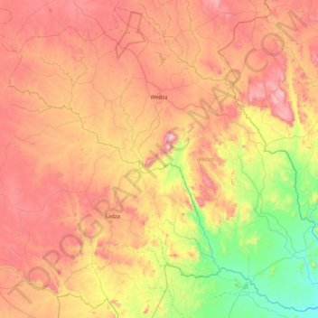
Name: Wedza topographic map, elevation, terrain.
Location: Wedza, Mashonaland East, Zimbabwe (-19.12513 31.19691 -18.41100 31.98536)
Average elevation: 1,233 m
Minimum elevation: 806 m
Maximum elevation: 1,714 m
Other topographic maps
Click on a map to view its topography, its elevation and its terrain.
Melfort
Zimbabwe > Mashonaland East > Goromonzi > Melfort
Melfort, Goromonzi, Mashonaland East, Zimbabwe
Average elevation: 1,517 m
Mudzimu Noiringe
Mudzimu Noiringe, Goromonzi, Mashonaland East, Zimbabwe
Average elevation: 1,257 m
Chitora
Chitora, Mutoko, Mashonaland East, Zimbabwe
Average elevation: 1,113 m