
Royal Leamington Spa topographic map
Interactive map
Click on the map to display elevation.
About this map
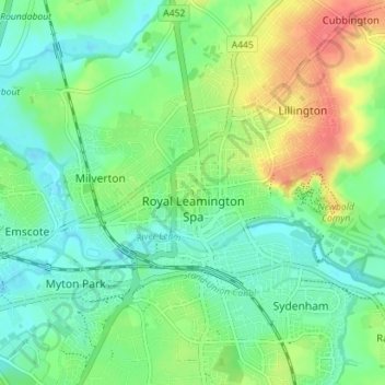
Name: Royal Leamington Spa topographic map, elevation, terrain.
Average elevation: 66 m
Minimum elevation: 47 m
Maximum elevation: 100 m
Other topographic maps
Click on a map to view its topography, its elevation and its terrain.
Edstone
United Kingdom > England > Warwickshire > Stratford-on-Avon > Wootton Wawen CP
Average elevation: 90 m
Ascott
United Kingdom > England > Warwickshire > Stratford-on-Avon > Whichford
Average elevation: 160 m
Brook End
United Kingdom > England > Warwickshire > North Warwickshire > Hurley
Average elevation: 107 m
Vale View
United Kingdom > England > Warwickshire > Nuneaton and Bedworth > Nuneaton
Average elevation: 113 m
Walton
United Kingdom > England > Warwickshire > Stratford-on-Avon > Wellesbourne
Average elevation: 76 m
Rowington Green
United Kingdom > England > Warwickshire > Warwick > Rowington
Average elevation: 114 m
Brinklow Marina
United Kingdom > England > Warwickshire > Rugby > King's Newnham CP
Average elevation: 95 m
Sutton-under-Brailes
United Kingdom > England > Warwickshire > Stratford-on-Avon > Stourton
Average elevation: 125 m
Edgehill
United Kingdom > England > Warwickshire > Stratford-on-Avon > Radway
Average elevation: 157 m
Nuneaton Common
United Kingdom > England > Warwickshire > Nuneaton and Bedworth
Average elevation: 127 m
Church End
United Kingdom > England > Warwickshire > North Warwickshire > Ansley CP
Average elevation: 151 m
Oversley Wood
United Kingdom > England > Warwickshire > Stratford-on-Avon > Alcester > Exhall
Average elevation: 64 m
Merevale Lake
United Kingdom > England > Warwickshire > North Warwickshire > Atherstone
Average elevation: 119 m
Curdworth Locks
United Kingdom > England > Warwickshire > North Warwickshire > Kingsbury > Curdworth CP
Average elevation: 80 m
Burton Dassett Hills Country Park
United Kingdom > England > Warwickshire > Stratford-on-Avon > Northend > Burton Dassett CP
Average elevation: 132 m
Cranhill
United Kingdom > England > Warwickshire > Stratford-on-Avon > Ardens Grafton
Average elevation: 57 m
Hartshill Hayes Country Park
United Kingdom > England > Warwickshire > North Warwickshire > Ansley Common
Average elevation: 127 m
Lye Green
United Kingdom > England > Warwickshire > Stratford-on-Avon > Claverdon > Lye Green
Average elevation: 106 m
Winderton
United Kingdom > England > Warwickshire > Stratford-on-Avon > Winderton
Average elevation: 151 m
Upper Quinton
United Kingdom > England > Warwickshire > Stratford-on-Avon > Lower Quinton > Upper Quinton
Average elevation: 70 m
Hampton on the Hill
United Kingdom > England > Warwickshire > Warwick > Hampton on the Hill
Average elevation: 75 m
Bishop's Itchington
United Kingdom > England > Warwickshire > Stratford-on-Avon
Average elevation: 105 m
Ladbroke (Millennium Green)
United Kingdom > England > Warwickshire > Stratford-on-Avon > Ladbroke CP
Average elevation: 98 m
Horeston Grange
United Kingdom > England > Warwickshire > Nuneaton and Bedworth
Average elevation: 90 m
Lower Tysoe
United Kingdom > England > Warwickshire > Stratford-on-Avon > Middle Tysoe
Average elevation: 127 m
Tredington
United Kingdom > England > Warwickshire > Stratford-on-Avon > Tredington
Average elevation: 73 m
Pillerton Hersey
United Kingdom > England > Warwickshire > Stratford-on-Avon > Pillerton Hersey
Average elevation: 92 m
Pathlow
United Kingdom > England > Warwickshire > Stratford-on-Avon > Wilmcote CP
Average elevation: 84 m
Napton on the Hill
United Kingdom > England > Warwickshire > Stratford-on-Avon
Average elevation: 113 m
Lower Binton
United Kingdom > England > Warwickshire > Stratford-on-Avon > Binton
Average elevation: 52 m
Pooley Country Park
United Kingdom > England > Warwickshire > North Warwickshire > Polesworth
Average elevation: 76 m
Lea Marston Purification Lakes
United Kingdom > England > Warwickshire > North Warwickshire > Marston
Average elevation: 70 m