
East Calder topographic map
Interactive map
Click on the map to display elevation.
About this map
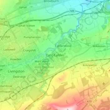
Name: East Calder topographic map, elevation, terrain.
Location: East Calder, West Lothian, Scotland, EH53 0EL, United Kingdom (55.85495 -3.50429 55.93495 -3.42429)
Average elevation: 140 m
Minimum elevation: 38 m
Maximum elevation: 346 m
Other topographic maps
Click on a map to view its topography, its elevation and its terrain.
Whitburn
United Kingdom > Scotland > West Lothian
Whitburn, West Lothian, Scotland, EH47 0QA, United Kingdom
Average elevation: 191 m
Livingston
United Kingdom > Scotland > West Lothian
Livingston, West Lothian, Scotland, EH54 6HS, United Kingdom
Average elevation: 158 m
Ecclesmachan
United Kingdom > Scotland > West Lothian
Ecclesmachan, West Lothian, Scotland, EH52 6NG, United Kingdom
Average elevation: 118 m
Mid Calder
United Kingdom > Scotland > West Lothian
Mid Calder, West Lothian, Scotland, EH53 0AN, United Kingdom
Average elevation: 134 m