
Thank you for supporting this site ❤️
Make a donation
Make a donation
Holsworthy topographic map
Click on the map to display elevation.
Thank you for supporting this site ❤️
Make a donation
Make a donation
About this map
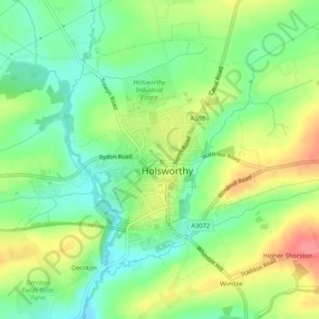
Name: Holsworthy topographic map, elevation, terrain.
Average elevation: 132 m
Minimum elevation: 100 m
Maximum elevation: 177 m
Thank you for supporting this site ❤️
Make a donation
Make a donation
Other topographic maps
Click on a map to view its topography, its elevation and its terrain.
Thank you for supporting this site ❤️
Make a donation
Make a donation
Hartland Point
United Kingdom > England > Devon > Torridge District > Hartland
Average elevation: 20 m
Thank you for supporting this site ❤️
Make a donation
Make a donation
Thank you for supporting this site ❤️
Make a donation
Make a donation
Woollaton
United Kingdom > England > Devon > Torridge District > Peters Marland
Average elevation: 138 m
Thank you for supporting this site ❤️
Make a donation
Make a donation