
Blagdon topographic map
Interactive map
Click on the map to display elevation.
About this map
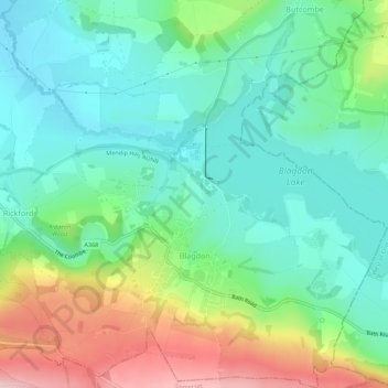
Name: Blagdon topographic map, elevation, terrain.
Location: Blagdon, North Somerset, England, United Kingdom (51.31615 -2.74018 51.35047 -2.68718)
Average elevation: 96 m
Minimum elevation: 21 m
Maximum elevation: 262 m
Other topographic maps
Click on a map to view its topography, its elevation and its terrain.
Clevedon
United Kingdom > England > North Somerset
Clevedon, North Somerset, England, United Kingdom
Average elevation: 10 m
Barrow Gurney
United Kingdom > England > North Somerset
Barrow Gurney, North Somerset, England, United Kingdom
Average elevation: 115 m
Weston-super-Mare
United Kingdom > England > North Somerset
Weston-super-Mare, North Somerset, England, United Kingdom
Average elevation: 9 m
Congresbury
United Kingdom > England > North Somerset > Congresbury
Congresbury, North Somerset, England, United Kingdom
Average elevation: 25 m
Wraxall
United Kingdom > England > North Somerset
Wraxall, North Somerset, England, BS48 1LD, United Kingdom
Average elevation: 74 m