
Yamanouchi topographic map
Interactive map
Click on the map to display elevation.
About this map
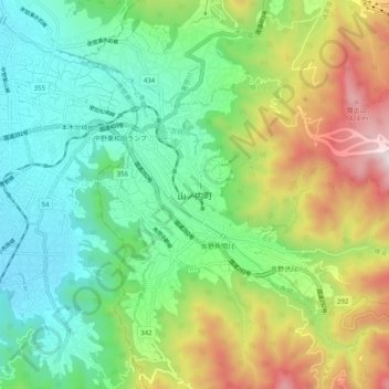
Name: Yamanouchi topographic map, elevation, terrain.
Average elevation: 726 m
Minimum elevation: 333 m
Maximum elevation: 1,519 m
Other topographic maps
Click on a map to view its topography, its elevation and its terrain.
Biwa Lake
Japan > Chubu Region > Yamanouchi
Biwa Lake, National Route 292, Yamanouchi, Shimotakai County, Nagano Prefecture, Chubu Region, 381-0401, Japan
Average elevation: 1,368 m