
Goose Island topographic map
Interactive map
Click on the map to display elevation.
About this map
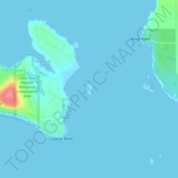
Name: Goose Island topographic map, elevation, terrain.
Location: Goose Island, San Juan County, Washington, United States (48.45703 -122.95785 48.45870 -122.95633)
Average elevation: 6 m
Minimum elevation: 0 m
Maximum elevation: 91 m
Other topographic maps
Click on a map to view its topography, its elevation and its terrain.
San Juan Island
United States > Washington > San Juan County > Friday Harbor
San Juan Island, Friday Harbor, San Juan County, Washington, 98250, United States
Average elevation: 26 m
Lopez Island
United States > Washington > San Juan County > Lopez Village
Lopez Island, Lopez Village, San Juan County, Washington, 98261, United States
Average elevation: 21 m
Orcas Island
United States > Washington > San Juan County > Eastsound
Orcas Island, Eastsound, San Juan County, Washington, United States
Average elevation: 59 m
Mount Dallas
United States > Washington > San Juan County
Mount Dallas, San Juan County, Washington, United States
Average elevation: 134 m
Blakely Island
United States > Washington > San Juan County
Blakely Island, San Juan County, Washington, 98222, United States
Average elevation: 60 m
Decatur Island
United States > Washington > San Juan County
Decatur Island, San Juan County, Washington, United States
Average elevation: 22 m
Friday Harbor
United States > Washington > San Juan County
Friday Harbor, San Juan County, Washington, 98250, United States
Average elevation: 28 m
Shaw Island
United States > Washington > San Juan County
Shaw Island, San Juan County, Washington, 98286, United States
Average elevation: 23 m
Orcas
United States > Washington > San Juan County
Orcas, San Juan County, Washington, 98280, United States
Average elevation: 39 m
Eastsound
United States > Washington > San Juan County
Eastsound, San Juan County, Washington, 98245, United States
Average elevation: 74 m