
Yunga topographic map
Interactive map
Click on the map to display elevation.
About this map
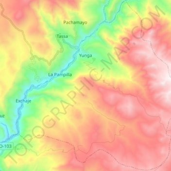
Name: Yunga topographic map, elevation, terrain.
Location: Yunga, General Sánchez Cerro, Moquegua, Pérou (-16.28164 -70.73185 -16.15403 -70.59826)
Average elevation: 4,253 m
Minimum elevation: 3,431 m
Maximum elevation: 5,021 m
Other topographic maps
Click on a map to view its topography, its elevation and its terrain.
Volcán Ticsani
Pérou > Moquegua > Cuchumbaya
Volcán Ticsani, Cuchumbaya, Mariscal Nieto, Moquegua, Pérou
Average elevation: 4,995 m
General Sánchez Cerro
General Sánchez Cerro, Matalaque, General Sánchez Cerro, Moquegua, Pérou
Average elevation: 3,660 m