
Bellevue topographic map
Interactive map
Click on the map to display elevation.
About this map
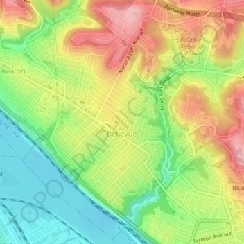
Name: Bellevue topographic map, elevation, terrain.
Location: Bellevue, Allegheny County, Pennsylvania, United States (40.48226 -80.06619 40.50823 -80.04454)
Average elevation: 285 m
Minimum elevation: 212 m
Maximum elevation: 365 m
According to the United States Census Bureau, the borough has a total area of 1.1 square miles (2.8 km2), of which 1.0 square mile (2.6 km2) is land and 0.1 square miles (0.26 km2), or 9.09%, is water. Its average elevation is 997 feet (304 m) above sea level.
Other topographic maps
Click on a map to view its topography, its elevation and its terrain.
Pleasant Hills
United States > Pennsylvania > Allegheny County
Pleasant Hills, Allegheny County, Pennsylvania, United States
Average elevation: 340 m
Warrendale
United States > Pennsylvania > Allegheny County
Warrendale, Marshall Township, Allegheny County, Pennsylvania, 15086, United States
Average elevation: 359 m
North Braddock
United States > Pennsylvania > Allegheny County
North Braddock, Allegheny County, Pennsylvania, 15104, United States
Average elevation: 282 m
Center
United States > Pennsylvania > Allegheny County > Plum
Center, Plum, Allegheny County, Pennsylvania, 15239, United States
Average elevation: 341 m
Clairton
United States > Pennsylvania > Allegheny County > Clairton
Clairton, Allegheny County, Pennsylvania, 15009:15025, United States
Average elevation: 281 m
Pittsburgh
United States > Pennsylvania > Allegheny County
Pittsburgh, Allegheny County, Pennsylvania, United States
Average elevation: 303 m
Elizabeth
United States > Pennsylvania > Allegheny County
Elizabeth, Allegheny County, Pennsylvania, United States
Average elevation: 273 m