
Moorhouse topographic map
Interactive map
Click on the map to display elevation.
About this map
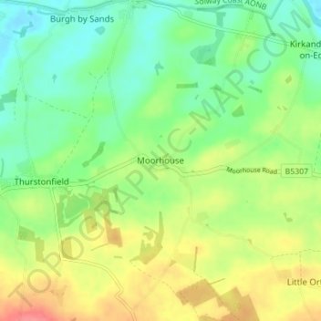
Name: Moorhouse topographic map, elevation, terrain.
Location: Moorhouse, Carlisle, Cumbria, England, CA5 6HA, United Kingdom (54.88229 -3.06408 54.92229 -3.02408)
Average elevation: 33 m
Minimum elevation: 6 m
Maximum elevation: 72 m
Other topographic maps
Click on a map to view its topography, its elevation and its terrain.
River Eden
United Kingdom > England > Cumbria > Carlisle > Great Corby
River Eden, Wetheral, Great Corby, Carlisle, Cumbria, England, United Kingdom
Average elevation: 52 m
Oatlands Plantation
United Kingdom > England > Cumbria > Carlisle > Rockcliffe
Oatlands Plantation, Rockcliffe, Carlisle, Cumbria, England, United Kingdom
Average elevation: 16 m
Rockcliffe
United Kingdom > England > Cumbria > Carlisle > Rockcliffe
Rockcliffe, Carlisle, Cumbria, North West England, England, United Kingdom
Average elevation: 20 m