
Thank you for supporting this site ❤️
Make a donation
Make a donation
Spencers Wood topographic map
Click on the map to display elevation.
Thank you for supporting this site ❤️
Make a donation
Make a donation
About this map
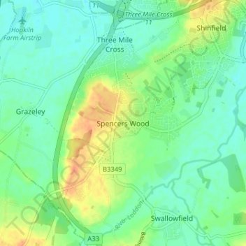
Name: Spencers Wood topographic map, elevation, terrain.
Average elevation: 49 m
Minimum elevation: 36 m
Maximum elevation: 74 m
Thank you for supporting this site ❤️
Make a donation
Make a donation
Other topographic maps
Click on a map to view its topography, its elevation and its terrain.
Thank you for supporting this site ❤️
Make a donation
Make a donation
Thank you for supporting this site ❤️
Make a donation
Make a donation
Finchampstead Ridges
United Kingdom > England > Borough of Wokingham > Finchampstead
Average elevation: 72 m
Thank you for supporting this site ❤️
Make a donation
Make a donation
Thank you for supporting this site ❤️
Make a donation
Make a donation
Thank you for supporting this site ❤️
Make a donation
Make a donation