
Chambroye topographic map
Interactive map
Click on the map to display elevation.
About this map
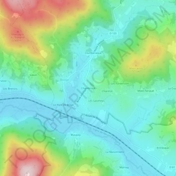
Name: Chambroye topographic map, elevation, terrain.
Average elevation: 389 m
Minimum elevation: 284 m
Maximum elevation: 651 m
Other topographic maps
Click on a map to view its topography, its elevation and its terrain.
Chapey
France > Bourgogne-Franche-Comté > Saône-et-Loire > Broye
Chapey, Broye, Autun, Saône-et-Loire, Bourgogne-Franche-Comté, France métropolitaine, 71190, France
Average elevation: 441 m
Velay
France > Bourgogne-Franche-Comté > Saône-et-Loire > Broye
Velay, Broye, Autun, Saône-et-Loire, Bourgogne-Franche-Comté, France métropolitaine, 71190, France
Average elevation: 455 m
Signal du Montjeu
France > Bourgogne-Franche-Comté > Saône-et-Loire > Broye
Signal du Montjeu, Broye, Autun, Saône-et-Loire, Bourgogne-Franche-Comté, France métropolitaine, 71190, France
Average elevation: 550 m
La Mouille Lotte
France > Bourgogne-Franche-Comté > Saône-et-Loire > Broye > Mont Fenaud
La Mouille Lotte, Mont Fenaud, Broye, Autun, Saône-et-Loire, Bourgogne-Franche-Comté, France métropolitaine, 71190, France
Average elevation: 381 m