
Oklahoma City topographic map
Interactive map
Click on the map to display elevation.
About this map
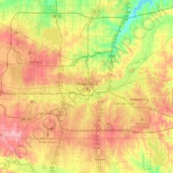
Name: Oklahoma City topographic map, elevation, terrain.
Average elevation: 370 m
Minimum elevation: 306 m
Maximum elevation: 432 m
Other topographic maps
Click on a map to view its topography, its elevation and its terrain.
Scissortail Park
United States > Oklahoma > Oklahoma County > Oklahoma City
Scissortail Park, 300, Oklahoma City, Oklahoma County, Oklahoma, United States
Average elevation: 365 m
Lake Hefner
United States > Oklahoma > Oklahoma County > Oklahoma City
Lake Hefner, Oklahoma City, Oklahoma County, Oklahoma, United States
Average elevation: 368 m