
Kenora District topographic map
Interactive map
Click on the map to display elevation.
About this map
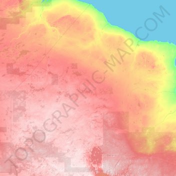
Name: Kenora District topographic map, elevation, terrain.
Location: Kenora District, Northwestern Ontario, Ontario, Canada (49.00100 -95.15374 56.85936 -81.48026)
Average elevation: 208 m
Minimum elevation: -1 m
Maximum elevation: 550 m
Other topographic maps
Click on a map to view its topography, its elevation and its terrain.
Première Nation de Lac Seul
Canada > Ontario > Kenora District > Unorganized Kenora District
Première Nation de Lac Seul, Unorganized Kenora District, Kenora District, Northwestern Ontario, Ontario, Canada
Average elevation: 371 m
Kenora
Canada > Ontario > Kenora District
Kenora, Kenora District, Northwestern Ontario, Ontario, Canada
Average elevation: 336 m