
Provincia de Talca topographic map
Interactive map
Click on the map to display elevation.
About this map
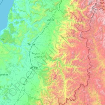
Name: Provincia de Talca topographic map, elevation, terrain.
Location: Provincia de Talca, Región del Maule, Chile (-36.17893 -72.61934 -34.97106 -70.30761)
Average elevation: 1,183 m
Minimum elevation: 0 m
Maximum elevation: 4,868 m
Other topographic maps
Click on a map to view its topography, its elevation and its terrain.
Peuño
Chile > Región del Maule > Pelluhue > Peuño
Peuño, Pelluhue, Provincia de Cauquenes, Región del Maule, Chile
Average elevation: 42 m