
Beeler Mill topographic map
Interactive map
Click on the map to display elevation.
About this map
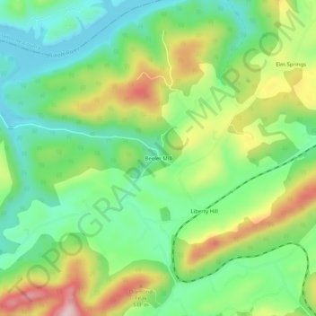
Name: Beeler Mill topographic map, elevation, terrain.
Average elevation: 402 m
Minimum elevation: 301 m
Maximum elevation: 571 m
Other topographic maps
Click on a map to view its topography, its elevation and its terrain.
Blaine
United States > Tennessee > Grainger County
Blaine, Grainger County, East Tennessee, Tennessee, 37709, United States
Average elevation: 332 m
Rock Haven
United States > Tennessee > Grainger County
Rock Haven, Grainger County, East Tennessee, Tennessee, United States
Average elevation: 443 m
Cherokee Lake
United States > Tennessee > Grainger County > Bean Station
Cherokee Lake, Bean Station, Grainger County, East Tennessee, Tennessee, United States
Average elevation: 394 m
Washburn
United States > Tennessee > Grainger County
Washburn, Grainger County, East Tennessee, Tennessee, United States
Average elevation: 465 m
Bean Station
United States > Tennessee > Grainger County > Bean Station > Bean Station
Bean Station, Grainger County, Tennessee, 37708, United States
Average elevation: 390 m
Bean Station
United States > Tennessee > Grainger County
Bean Station, Grainger County, East Tennessee, Tennessee, United States
Average elevation: 356 m
Rutledge
United States > Tennessee > Grainger County
Rutledge, Grainger County, East Tennessee, Tennessee, 37861, United States
Average elevation: 405 m
Rutledge
United States > Tennessee > Grainger County > Rutledge > Rutledge
Rutledge, Grainger County, Tennessee, United States
Average elevation: 393 m
Thorn Hill
United States > Tennessee > Grainger County
Thorn Hill, Grainger County, East Tennessee, Tennessee, United States
Average elevation: 474 m