
Trient topographic map
Interactive map
Click on the map to display elevation.
About this map
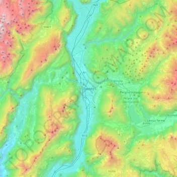
Name: Trient topographic map, elevation, terrain.
Average elevation: 970 m
Minimum elevation: 93 m
Maximum elevation: 3,117 m
Die Stadt liegt, umgeben von Bergen, im Etschtal direkt an der Etsch, 55 km südlich von Bozen und 100 km nördlich von Verona. Ihr Zentrum befindet sich auf einer Höhe von 194 m ü. NHN. Das Gemeindegebiet erstreckt sich über eine Fläche von 158 km².
Other topographic maps
Click on a map to view its topography, its elevation and its terrain.
Vason
Italien > Trentino-Südtirol > Autonome Provinz Trient > Trient
Vason, Trient, Territorio Val d'Adige, Autonome Provinz Trient, Trentino-Südtirol, Italien
Average elevation: 1,344 m
Vaneze
Italien > Trentino-Südtirol > Autonome Provinz Trient > Trient
Vaneze, Trient, Territorio Val d'Adige, Autonome Provinz Trient, Trentino-Südtirol, Italien
Average elevation: 1,014 m
Candriai
Italien > Trentino-Südtirol > Autonome Provinz Trient > Trient > Sardagna
Candriai, Sardagna, Trient, Territorio Val d'Adige, Autonome Provinz Trient, Trentino-Südtirol, 38122, Italien
Average elevation: 744 m
Sopramonte
Italien > Trentino-Südtirol > Autonome Provinz Trient > Trient
Sopramonte, Trient, Territorio Val d'Adige, Autonome Provinz Trient, Trentino-Südtirol, Italien
Average elevation: 718 m