
Iskanderiya topographic map
Interactive map
Click on the map to display elevation.
About this map
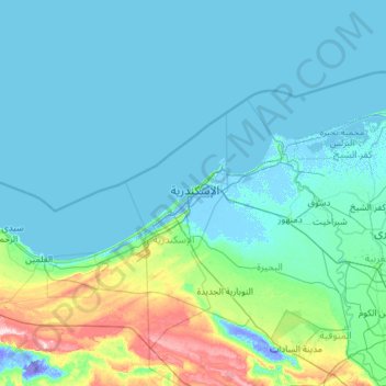
Name: Iskanderiya topographic map, elevation, terrain.
Location: Iskanderiya, Alexandria, 21573, Egypt (30.16667 28.88333 32.16667 30.88333)
Average elevation: 19 m
Minimum elevation: -38 m
Maximum elevation: 221 m
Other topographic maps
Click on a map to view its topography, its elevation and its terrain.
Qism al Gumruk
Egypt > Alexandria > Alexandria
Qism al Gumruk, Alexandria, 21562, Egypt
Average elevation: 4 m
El Shallalat
Egypt > Alexandria > Alexandria > Shatby
El Shallalat, Shatby, Alexandria, 21526, Egypt
Average elevation: 11 m