
Sermersooq topographic map
Interactive map
Click on the map to display elevation.
About this map
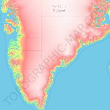
Name: Sermersooq topographic map, elevation, terrain.
Location: Sermersooq, Greenland (60.85019 -52.79009 71.94284 -20.78094)
Average elevation: 1,116 m
Minimum elevation: -2 m
Maximum elevation: 3,402 m
Other topographic maps
Click on a map to view its topography, its elevation and its terrain.
Nuuk
Nuuk's sports clubs include Nuuk IL (established in 1934), B-67, and GSS Nuuk. Nuuk Stadium is a multi-purpose stadium, used mostly for football games. The stadium has a capacity of 2,000. The stadium can also be used as an entertainment venue: the Scottish rock band Nazareth performed at the venue. Nuuk also…
Average elevation: 76 m