
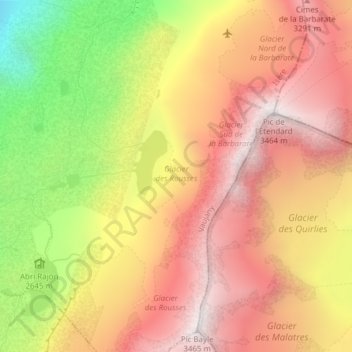
Glacier des Rousses topographic map
Interactive map
Click on the map to display elevation.
About this map
Name: Glacier des Rousses topographic map, elevation, terrain.
Average elevation: 2,883 m
Minimum elevation: 2,062 m
Maximum elevation: 3,445 m
Other topographic maps
Click on a map to view its topography, its elevation and its terrain.
Rif Jany
France > Auvergne-Rhône-Alpes > Vaujany > Rif Jany
Rif Jany, Vaujany, Grenoble, Isère, Auvergne-Rhône-Alpes, France métropolitaine, 38114, France
Average elevation: 1,187 m
Lac du Cos
France > Auvergne-Rhône-Alpes > Vaujany
Lac du Cos, La Ferrière, Vaujany, Grenoble, Isère, Auvergne-Rhône-Alpes, France métropolitaine, 38114, France
Average elevation: 2,335 m
Lac Gris
France > Auvergne-Rhône-Alpes > Vaujany
Lac Gris, Crazy Mustang, Vaujany, Grenoble, Isère, Auvergne-Rhône-Alpes, France métropolitaine, 38114, France
Average elevation: 2,677 m
Lac de Cottepens
France > Auvergne-Rhône-Alpes > Vaujany
Lac de Cottepens, Col Agnelin, La Ferrière, Vaujany, Grenoble, Isère, Auvergne-Rhône-Alpes, France métropolitaine, 38580, France
Average elevation: 2,277 m
Col du Rocher Blanc
France > Auvergne-Rhône-Alpes > Vaujany
Col du Rocher Blanc, Col Agnelin, La Ferrière, Vaujany, Grenoble, Isère, Auvergne-Rhône-Alpes, France métropolitaine, 38580, France
Average elevation: 2,492 m
Lac du Cos
France > Auvergne-Rhône-Alpes > Vaujany
Lac du Cos, Col Agnelin, La Ferrière, Vaujany, Grenoble, Isère, Auvergne-Rhône-Alpes, France métropolitaine, 38580, France
Average elevation: 2,335 m