
Ruapuke Islands topographic map
Interactive map
Click on the map to display elevation.
About this map
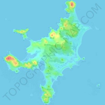
Name: Ruapuke Islands topographic map, elevation, terrain.
Location: Ruapuke Islands, Invercargill, Southland, New Zealand (-46.79963 168.47106 -46.73516 168.54900)
Average elevation: 4 m
Minimum elevation: -5 m
Maximum elevation: 64 m
Other topographic maps
Click on a map to view its topography, its elevation and its terrain.
Hokonui Hills
Hokonui Hills, Invercargill, Southland, New Zealand
Average elevation: 451 m
Taramoa
New Zealand > Invercargill > Taramoa
Taramoa, Invercargill, Southland, New Zealand
Average elevation: 8 m
Waitokariro Lagoon
Waitokariro Lagoon, Invercargill, Invercargill City, Southland, New Zealand
Average elevation: 7 m
Tauatemaku Lagoon
Tauatemaku Lagoon, Invercargill, Invercargill City, Southland, New Zealand
Average elevation: 5 m