
Saint-Nizier topographic map
Interactive map
Click on the map to display elevation.
About this map
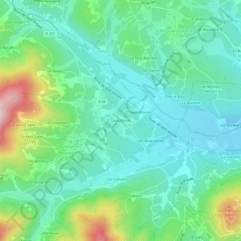
Name: Saint-Nizier topographic map, elevation, terrain.
Average elevation: 316 m
Minimum elevation: 225 m
Maximum elevation: 576 m
Other topographic maps
Click on a map to view its topography, its elevation and its terrain.
Les Samsons
France > Auvergne-Rhône-Alpes > Rhône > Quincié-en-Beaujolais
Les Samsons, Quincié-en-Beaujolais, Villefranche-sur-Saône, Rhône, Auvergne-Rhône-Alpes, France métropolitaine, 69430, France
Average elevation: 342 m
Les Vayvolets
France > Auvergne-Rhône-Alpes > Rhône > Quincié-en-Beaujolais
Les Vayvolets, Quincié-en-Beaujolais, Villefranche-sur-Saône, Rhône, Circonscription départementale du Rhône, Auvergne-Rhône-Alpes, France métropolitaine, 69430, France
Average elevation: 355 m
Vitry
France > Auvergne-Rhône-Alpes > Rhône > Quincié-en-Beaujolais
Vitry, Quincié-en-Beaujolais, Villefranche-sur-Saône, Rhône, Auvergne-Rhône-Alpes, France métropolitaine, 69430, France
Average elevation: 422 m