
Starvation State Park topographic map
Interactive map
Click on the map to display elevation.
About this map
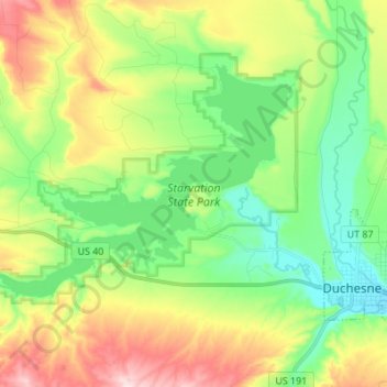
Name: Starvation State Park topographic map, elevation, terrain.
Average elevation: 1,786 m
Minimum elevation: 1,675 m
Maximum elevation: 1,979 m
Other topographic maps
Click on a map to view its topography, its elevation and its terrain.
Fruitland
United States > Utah > Duchesne County
Fruitland, Duchesne County, Utah, 84027, United States
Average elevation: 2,028 m
Roosevelt
United States > Utah > Duchesne County
Roosevelt, Duchesne County, Utah, 84066, United States
Average elevation: 1,553 m
High Uintas Wilderness
United States > Utah > Duchesne County
High Uintas Wilderness, Duchesne County, Utah, United States
Average elevation: 2,919 m