
San Nicandro Garganico topographic map
Interactive map
Click on the map to display elevation.
About this map
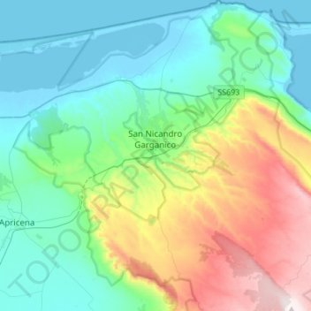
Name: San Nicandro Garganico topographic map, elevation, terrain.
Location: San Nicandro Garganico, Foggia, Apulien, Italien (41.72601 15.45501 41.92928 15.67674)
Average elevation: 263 m
Minimum elevation: -7 m
Maximum elevation: 1,005 m
San Nicandro Garganico liegt unweit des Sees von Lesina, nahe der Küste der Adria. Die Nachbargemeinden sind Apricena, Cagnano Varano, Lesina, Poggio Imperiale und San Marco in Lamis. Die Stadt liegt mitten im Naturschutzgebiet Nationalpark Gargano. Die Stadt liegt auf 220 Höhenmeter. Die Entfernung zum Meer beträgt auf der Landstraße ca. 12 km. Nach San Giovanni Rotondo der Wirkungsstätte des Heiligen Padre Pio sind es ca. 30 km.
Other topographic maps
Click on a map to view its topography, its elevation and its terrain.
Marina di Lesina
Marina di Lesina, Lesina, Foggia, Apulien, Italien
Average elevation: 1 m