
Make a donation
Sumgayit topographic map
Click on the map to display elevation.
Make a donation
About this map
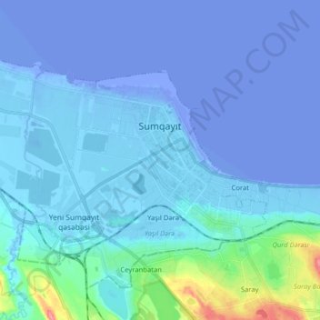
Name: Sumgayit topographic map, elevation, terrain.
Location: Sumgayit, Sumqayit, Azerbaijan (40.54410 49.56428 40.62214 49.72240)
Average elevation: -7 m
Minimum elevation: -30 m
Maximum elevation: 82 m
Make a donation
Other topographic maps
Click on a map to view its topography, its elevation and its terrain.
Make a donation
Make a donation
Make a donation
Make a donation
Make a donation
Gazakh
Gazakh region is located in the western part of the republic, in the western part of the vast Ganja-Gazakh plain, which starts from the slopes of the mountain range of the Lesser Caucasus and extends along the right bank of the Kura river. The highest elevation is "Odun" mountain (1316 meters). Its nature is…
Average elevation: 376 m
Gadabay
Gadabay lies at the northern foot of the Shahdagh Range, at an altitude of 1460 meters, on the coast of the Mis River. The city is located in the middle and high mountainous areas of the Lesser Caucasus (also called Little Caucasus).
Average elevation: 1,504 m
Make a donation
Guba
Quba (Azerbaijani pronunciation: [guba]) is a city and the administrative centre of the Quba District of Azerbaijan. The city lies on the north-eastern slopes of Shahdag mountain, at an altitude of 600 metres above sea level, on the right bank of the Kudyal river. It has a population of 47,200 (2023).
Average elevation: 623 m
Make a donation
Make a donation
Make a donation
Gadabay
Gadabay lies at the northern foot of the Shahdagh Range, at an altitude of 1460 meters, on the coast of the Mis River. The city is located in the middle and high mountainous areas of the Lesser Caucasus (also called Little Caucasus).
Average elevation: 1,504 m
Make a donation
Make a donation
Gazakh
Gazakh region is located in the western part of the republic, in the western part of the vast Ganja-Gazakh plain, which starts from the slopes of the mountain range of the Lesser Caucasus and extends along the right bank of the Kura river. The highest elevation is "Odun" mountain (1316 meters). Its nature is…
Average elevation: 376 m
Make a donation
Make a donation
Khankendi
Stepanakert is located on the Karabakh plateau, at an average altitude of 813 m (2,667 ft) above sea level.
Average elevation: 862 m
Make a donation
Make a donation
Shamakhi
Shamakhi is located in the central part of Shirvan, at an altitude of about 749 m (2,457 ft) above sea level, in a favorable geographical position. In the south of Shamakhi flows to Zongalavay, and in the east Pirsaatchay. The city is surrounded by Binasli, Gushhan from the north, Pirdiraki, and Maiden…
Average elevation: 723 m
Make a donation
Guba
Quba (Guba) is a city and the administrative centre of the Quba District of Azerbaijan. The city lies on the north-eastern slopes of Shahdag mountain, at an altitude of 600 metres above sea level, on the right bank of the Kudyal river. It has a population of 47,200 (2023).
Average elevation: 623 m
Make a donation
Make a donation
Make a donation
Make a donation
Khyrdalan
Khyrdalan is located in the western part of the Absheron Peninsula, south of the Jeyranbatan Reservoir, between Baku and Sumgait, at an elevation of 71 meters above sea level. It lies just 5 kilometers from Baku and is situated in a seismically active region, with an earthquake intensity of 8 points on the…
Average elevation: 79 m
Make a donation