
Waldport topographic map
Interactive map
Click on the map to display elevation.
About this map
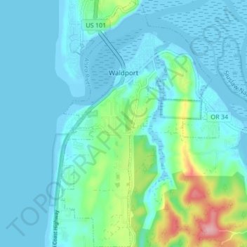
Name: Waldport topographic map, elevation, terrain.
Location: Waldport, Lincoln County, Oregon, 97394, United States (44.39259 -124.08478 44.44127 -124.04081)
Average elevation: 21 m
Minimum elevation: -9 m
Maximum elevation: 131 m
Other topographic maps
Click on a map to view its topography, its elevation and its terrain.
Seal Rock State Recreation Site
United States > Oregon > Lincoln County > Seal Rock
Average elevation: 16 m