
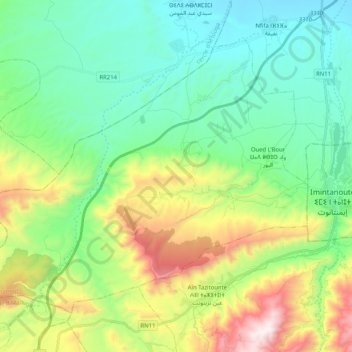
Oued L'Bour topographic map
Interactive map
Click on the map to display elevation.
About this map
Name: Oued L'Bour topographic map, elevation, terrain.
Average elevation: 1,033 m
Minimum elevation: 665 m
Maximum elevation: 1,920 m
Other topographic maps
Click on a map to view its topography, its elevation and its terrain.
Nfifa
Nfifa, caïdat de Nfifa-Ouad L’Bour, cercle d'Imintanout, Province de Chichaoua, Marrakech-Safi, Maroc
Average elevation: 751 m