
Bridgefoot topographic map
Interactive map
Click on the map to display elevation.
About this map
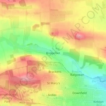
Name: Bridgefoot topographic map, elevation, terrain.
Location: Bridgefoot, Angus, Scotland, DD3 0TA, United Kingdom (56.48529 -3.03408 56.52529 -2.99408)
Average elevation: 125 m
Minimum elevation: 67 m
Maximum elevation: 177 m
Other topographic maps
Click on a map to view its topography, its elevation and its terrain.
Brechin
United Kingdom > Scotland > Angus
Brechin, Angus, Scotland, DD9 6ET, United Kingdom
Average elevation: 71 m
Montrose
United Kingdom > Scotland > Angus
Montrose, Angus, Scotland, DD10 8QW, United Kingdom
Average elevation: 22 m
Eassie
United Kingdom > Scotland > Angus
Eassie, Angus, Scotland, DD8 1SG, United Kingdom
Average elevation: 73 m
Fern
United Kingdom > Scotland > Angus
Fern, Angus, Scotland, DD8 3QW, United Kingdom
Average elevation: 156 m
Padanaram
United Kingdom > Scotland > Angus > Padanaram
Padanaram, Angus, Scotland, DD8 1PT, United Kingdom
Average elevation: 68 m