
Limal topographic map
Interactive map
Click on the map to display elevation.
About this map
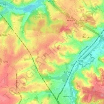
Name: Limal topographic map, elevation, terrain.
Location: Limal, Wavre, Nivelles, Brabant wallon, Wallonie, 1302, Belgique (50.68277 4.52970 50.72393 4.61475)
Average elevation: 86 m
Minimum elevation: 39 m
Maximum elevation: 137 m
Other topographic maps
Click on a map to view its topography, its elevation and its terrain.
Louvrange
Belgique > Brabant wallon > Nivelles > Wavre
Louvrange, Wavre, Nivelles, Brabant wallon, Wallonie, 1348, Belgique
Average elevation: 107 m
Basse-Wavre
Belgique > Brabant wallon > Nivelles > Wavre
Basse-Wavre, Wavre, Nivelles, Brabant wallon, Wallonie, 1300, Belgique
Average elevation: 74 m
Le Culot
Belgique > Brabant wallon > Nivelles > Wavre
Le Culot, Wavre, Nivelles, Brabant wallon, Wallonie, 1300, Belgique
Average elevation: 71 m