
Dolsenhain topographic map
Interactive map
Click on the map to display elevation.
About this map
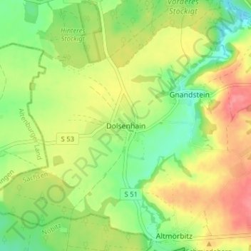
Name: Dolsenhain topographic map, elevation, terrain.
Location: Dolsenhain, Frohburg, Landkreis Leipzig, Sachsen, Deutschland (50.99222 12.53997 51.03222 12.57997)
Average elevation: 207 m
Minimum elevation: 172 m
Maximum elevation: 246 m
Die Flur von Dolsenhain weist ein Gefälle auf. Im Nordwesten liegt sie 208 Meter über NN, im Südosten sind es 244 Meter. Im Norden gibt es aber auch eine Höhe von nur 180 Meter über NN.
Other topographic maps
Click on a map to view its topography, its elevation and its terrain.
Frauendorf Bahnhof
Deutschland > Sachsen > Landkreis Leipzig > Frohburg
Frauendorf Bahnhof, Frohburg, Landkreis Leipzig, Sachsen, 04654, Deutschland
Average elevation: 204 m