
Orcières-Merlette topographic map
Interactive map
Click on the map to display elevation.
About this map
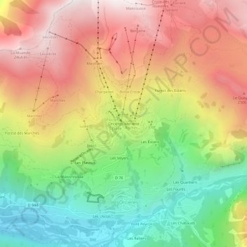
Name: Orcières-Merlette topographic map, elevation, terrain.
Average elevation: 1,874 m
Minimum elevation: 1,256 m
Maximum elevation: 2,509 m
Other topographic maps
Click on a map to view its topography, its elevation and its terrain.
Saut du Laïre
France > Provence-Alpes-Côte d'Azur > Hautes-Alpes > Orcières
Saut du Laïre, Orcières, Gap, Hautes-Alpes, Provence-Alpes-Côte d'Azur, France métropolitaine, 05170, France
Average elevation: 2,151 m
Les Usclas
France > Provence-Alpes-Côte d'Azur > Hautes-Alpes > Orcières
Les Usclas, Orcières, Gap, Hautes-Alpes, Provence-Alpes-Côte d'Azur, France métropolitaine, 05170, France, Accrobranche
Average elevation: 1,533 m
Prapic
France > Provence-Alpes-Côte d'Azur > Hautes-Alpes > Orcières
Prapic, Orcières, Gap, Hautes-Alpes, Provence-Alpes-Côte d'Azur, France métropolitaine, 05170, France
Average elevation: 2,001 m
Cabanes de la Terce
France > Provence-Alpes-Côte d'Azur > Hautes-Alpes > Orcières
Cabanes de la Terce, Orcières, Gap, Hautes-Alpes, Provence-Alpes-Côte d'Azur, France métropolitaine, 05170, France
Average elevation: 2,161 m
Pont Peyron
France > Provence-Alpes-Côte d'Azur > Hautes-Alpes > Orcières
Pont Peyron, Orcières, Gap, Hautes-Alpes, Provence-Alpes-Côte d'Azur, France métropolitaine, 05170, France
Average elevation: 1,714 m
Montcheny
France > Provence-Alpes-Côte d'Azur > Hautes-Alpes > Orcières
Montcheny, Orcières, Gap, Hautes-Alpes, Provence-Alpes-Côte d'Azur, France métropolitaine, 05170, France
Average elevation: 1,745 m
Archinard
France > Provence-Alpes-Côte d'Azur > Hautes-Alpes > Orcières
Archinard, Orcières, Gap, Hautes-Alpes, Provence-Alpes-Côte d'Azur, France métropolitaine, 05170, France
Average elevation: 1,876 m
Les Veyers
France > Provence-Alpes-Côte d'Azur > Hautes-Alpes > Orcières
Les Veyers, Orcières, Gap, Hautes-Alpes, Provence-Alpes-Côte d'Azur, France métropolitaine, 05170, France
Average elevation: 1,766 m
Les Usclas
France > Provence-Alpes-Côte d'Azur > Hautes-Alpes > Orcières
Les Usclas, Orcières, Gap, Hautes-Alpes, Provence-Alpes-Côte d'Azur, France métropolitaine, 05170, France
Average elevation: 1,660 m
Les Estaris
France > Provence-Alpes-Côte d'Azur > Hautes-Alpes > Orcières
Les Estaris, Orcières, Gap, Hautes-Alpes, Provence-Alpes-Côte d'Azur, France métropolitaine, 05170, France
Average elevation: 1,837 m
Les Audiberts
France > Provence-Alpes-Côte d'Azur > Hautes-Alpes > Orcières
Les Audiberts, Orcières, Gap, Hautes-Alpes, Provence-Alpes-Côte d'Azur, France métropolitaine, 05170, France
Average elevation: 1,719 m
Saut du Laire
France > Provence-Alpes-Côte d'Azur > Hautes-Alpes > Orcières
Saut du Laire, Orcières, Gap, Hautes-Alpes, Provence-Alpes-Côte d'Azur, France métropolitaine, 05170, France
Average elevation: 2,143 m