
Camps topographic map
Interactive map
Click on the map to display elevation.
About this map
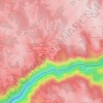
Name: Camps topographic map, elevation, terrain.
Average elevation: 505 m
Minimum elevation: 195 m
Maximum elevation: 594 m
Other topographic maps
Click on a map to view its topography, its elevation and its terrain.
Vidal
France > Nouvelle-Aquitaine > Corrèze > Camps-Saint-Mathurin-Léobazel > Camps
Vidal, Camps, Camps-Saint-Mathurin-Léobazel, Tulle, Corrèze, Nouvelle-Aquitaine, France métropolitaine, 19430, France
Average elevation: 508 m