
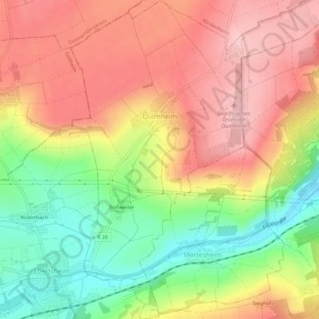
Quirnheim topographic map
Interactive map
Click on the map to display elevation.
About this map
Name: Quirnheim topographic map, elevation, terrain.
Average elevation: 243 m
Minimum elevation: 148 m
Maximum elevation: 318 m
Other topographic maps
Click on a map to view its topography, its elevation and its terrain.
Bad Dürkheim
Deutschland > Rheinland-Pfalz > Landkreis Bad Dürkheim
Bad Dürkheim, Landkreis Bad Dürkheim, Rheinland-Pfalz, 67098, Deutschland
Average elevation: 216 m
Dirmstein
Deutschland > Rheinland-Pfalz > Landkreis Bad Dürkheim
Dirmstein, Leiningerland, Landkreis Bad Dürkheim, Rheinland-Pfalz, 67246, Deutschland
Average elevation: 129 m
Hornesselwiese
Deutschland > Rheinland-Pfalz > Landkreis Bad Dürkheim > Elmstein
Hornesselwiese, Elmstein, Lambrecht (Pfalz), Landkreis Bad Dürkheim, Rheinland-Pfalz, 67471, Deutschland
Average elevation: 372 m
67454
Deutschland > Rheinland-Pfalz > Landkreis Bad Dürkheim > Haßloch
67454, Haßloch, Landkreis Bad Dürkheim, Rheinland-Pfalz, Deutschland
Average elevation: 114 m
67246
Deutschland > Rheinland-Pfalz > Landkreis Bad Dürkheim > Dirmstein
67246, Dirmstein, Leiningerland, Landkreis Bad Dürkheim, Rheinland-Pfalz, Deutschland
Average elevation: 127 m
Haßloch
Deutschland > Rheinland-Pfalz > Landkreis Bad Dürkheim
Haßloch, Landkreis Bad Dürkheim, Rheinland-Pfalz, 67454, Deutschland
Average elevation: 115 m
Tiefenthal
Deutschland > Rheinland-Pfalz > Landkreis Bad Dürkheim
Tiefenthal, Leiningerland, Landkreis Bad Dürkheim, Rheinland-Pfalz, 67311, Deutschland
Average elevation: 251 m
Frankeneck
Deutschland > Rheinland-Pfalz > Landkreis Bad Dürkheim
Frankeneck, Lambrecht (Pfalz), Landkreis Bad Dürkheim, Rheinland-Pfalz, Deutschland
Average elevation: 325 m
Bad Dürkheim
Deutschland > Rheinland-Pfalz > Landkreis Bad Dürkheim
Bad Dürkheim, Landkreis Bad Dürkheim, Rheinland-Pfalz, 67098, Deutschland, Isenachweiher
Average elevation: 315 m
Friedelsheim
Deutschland > Rheinland-Pfalz > Landkreis Bad Dürkheim
Friedelsheim, Wachenheim an der Weinstraße, Landkreis Bad Dürkheim, Rheinland-Pfalz, 67159, Deutschland
Average elevation: 124 m
Kirchheim an der Weinstraße
Deutschland > Rheinland-Pfalz > Landkreis Bad Dürkheim
Kirchheim an der Weinstraße, Leiningerland, Landkreis Bad Dürkheim, Rheinland-Pfalz, 67281, Deutschland
Average elevation: 193 m
Deidesheim
Deutschland > Rheinland-Pfalz > Landkreis Bad Dürkheim
Deidesheim, Landkreis Bad Dürkheim, Rheinland-Pfalz, 67146, Deutschland
Average elevation: 194 m
Grünstadt
Deutschland > Rheinland-Pfalz > Landkreis Bad Dürkheim
Grünstadt, Landkreis Bad Dürkheim, Rheinland-Pfalz, Deutschland
Average elevation: 208 m
Forst an der Weinstraße
Deutschland > Rheinland-Pfalz > Landkreis Bad Dürkheim
Forst an der Weinstraße, Deidesheim, Landkreis Bad Dürkheim, Rheinland-Pfalz, 67147, Deutschland
Average elevation: 171 m
Harzofen
Deutschland > Rheinland-Pfalz > Landkreis Bad Dürkheim > Appenthal
Harzofen, Appenthal, Elmstein, Lambrecht (Pfalz), Landkreis Bad Dürkheim, Rheinland-Pfalz, 67471, Deutschland
Average elevation: 348 m
Elsa Host-Brunnen
Deutschland > Rheinland-Pfalz > Landkreis Bad Dürkheim > Weidenthal
Elsa Host-Brunnen, B 39, Weidenthal, Lambrecht (Pfalz), Landkreis Bad Dürkheim, Rheinland-Pfalz, 67475, Deutschland
Average elevation: 326 m
Wachenheim an der Weinstraße
Deutschland > Rheinland-Pfalz > Landkreis Bad Dürkheim
Wachenheim an der Weinstraße, Landkreis Bad Dürkheim, Rheinland-Pfalz, 67157, Deutschland
Average elevation: 202 m
Mollenkopf
Deutschland > Rheinland-Pfalz > Landkreis Bad Dürkheim > Weidenthal
Mollenkopf, Weidenthal, Lambrecht (Pfalz), Landkreis Bad Dürkheim, Rheinland-Pfalz, 67472, Deutschland
Average elevation: 393 m
Lindenberg
Deutschland > Rheinland-Pfalz > Landkreis Bad Dürkheim
Lindenberg, Lambrecht (Pfalz), Landkreis Bad Dürkheim, Rheinland-Pfalz, 67473, Deutschland
Average elevation: 338 m
Iggelbach
Deutschland > Rheinland-Pfalz > Landkreis Bad Dürkheim
Iggelbach, Elmstein, Lambrecht (Pfalz), Landkreis Bad Dürkheim, Rheinland-Pfalz, 67471, Deutschland
Average elevation: 391 m
Weisenheim am Berg
Deutschland > Rheinland-Pfalz > Landkreis Bad Dürkheim
Weisenheim am Berg, Freinsheim, Landkreis Bad Dürkheim, Rheinland-Pfalz, 67273, Deutschland
Average elevation: 230 m
Geisskopf
Deutschland > Rheinland-Pfalz > Landkreis Bad Dürkheim > Elmstein
Geisskopf, Elmstein, Lambrecht (Pfalz), Landkreis Bad Dürkheim, Rheinland-Pfalz, 67471, Deutschland
Average elevation: 378 m
Hettenleidelheim
Deutschland > Rheinland-Pfalz > Landkreis Bad Dürkheim
Hettenleidelheim, Leiningerland, Landkreis Bad Dürkheim, Rheinland-Pfalz, 67310, Deutschland
Average elevation: 266 m
Gerolsheim
Deutschland > Rheinland-Pfalz > Landkreis Bad Dürkheim
Gerolsheim, Leiningerland, Landkreis Bad Dürkheim, Rheinland-Pfalz, Deutschland
Average elevation: 108 m
Lambrecht (Pfalz)
Deutschland > Rheinland-Pfalz > Landkreis Bad Dürkheim
Lambrecht (Pfalz), Landkreis Bad Dürkheim, Rheinland-Pfalz, Deutschland
Average elevation: 382 m
Dackenheim
Deutschland > Rheinland-Pfalz > Landkreis Bad Dürkheim > Dackenheim
Dackenheim, Freinsheim, Landkreis Bad Dürkheim, Rheinland-Pfalz, Deutschland
Average elevation: 188 m
Elmstein
Deutschland > Rheinland-Pfalz > Landkreis Bad Dürkheim
Elmstein, Lambrecht (Pfalz), Landkreis Bad Dürkheim, Rheinland-Pfalz, 67471, Deutschland
Average elevation: 385 m
Freinsheim
Deutschland > Rheinland-Pfalz > Landkreis Bad Dürkheim
Freinsheim, Landkreis Bad Dürkheim, Rheinland-Pfalz, 67251, Deutschland
Average elevation: 154 m
Carlsberg
Deutschland > Rheinland-Pfalz > Landkreis Bad Dürkheim
Carlsberg, Leiningerland, Landkreis Bad Dürkheim, Rheinland-Pfalz, 67316, Deutschland
Average elevation: 327 m
Lambrecht
Deutschland > Rheinland-Pfalz > Landkreis Bad Dürkheim
Lambrecht, Lambrecht (Pfalz), Landkreis Bad Dürkheim, Rheinland-Pfalz, 67466, Deutschland
Average elevation: 325 m
Ellerstadt
Deutschland > Rheinland-Pfalz > Landkreis Bad Dürkheim > Ellerstadt
Ellerstadt, Wachenheim an der Weinstraße, Landkreis Bad Dürkheim, Rheinland-Pfalz, 67158, Deutschland
Average elevation: 107 m
Weidenthal
Deutschland > Rheinland-Pfalz > Landkreis Bad Dürkheim
Weidenthal, Lambrecht (Pfalz), Landkreis Bad Dürkheim, Rheinland-Pfalz, 67475, Deutschland
Average elevation: 343 m
Hertlingshausen
Deutschland > Rheinland-Pfalz > Landkreis Bad Dürkheim
Hertlingshausen, Carlsberg, Leiningerland, Landkreis Bad Dürkheim, Rheinland-Pfalz, 67316, Deutschland
Average elevation: 331 m
Erpolzheim
Deutschland > Rheinland-Pfalz > Landkreis Bad Dürkheim
Erpolzheim, Freinsheim, Landkreis Bad Dürkheim, Rheinland-Pfalz, 67167, Deutschland
Average elevation: 110 m
Weisenheim am Sand
Deutschland > Rheinland-Pfalz > Landkreis Bad Dürkheim
Weisenheim am Sand, Freinsheim, Landkreis Bad Dürkheim, Rheinland-Pfalz, 67256, Deutschland
Average elevation: 133 m
Laumersheim
Deutschland > Rheinland-Pfalz > Landkreis Bad Dürkheim
Laumersheim, Leiningerland, Landkreis Bad Dürkheim, Rheinland-Pfalz, 67229, Deutschland
Average elevation: 124 m
Altleiningen
Deutschland > Rheinland-Pfalz > Landkreis Bad Dürkheim > Altleiningen
Altleiningen, Leiningerland, Landkreis Bad Dürkheim, Rheinland-Pfalz, 67317, Deutschland
Average elevation: 324 m
Herxheim am Berg
Deutschland > Rheinland-Pfalz > Landkreis Bad Dürkheim
Herxheim am Berg, Freinsheim, Landkreis Bad Dürkheim, Rheinland-Pfalz, Deutschland
Average elevation: 197 m
Esthal
Deutschland > Rheinland-Pfalz > Landkreis Bad Dürkheim > Esthal
Esthal, Lambrecht (Pfalz), Landkreis Bad Dürkheim, Rheinland-Pfalz, 67472, Deutschland
Average elevation: 351 m
Obrigheim (Pfalz)
Deutschland > Rheinland-Pfalz > Landkreis Bad Dürkheim
Obrigheim (Pfalz), Leiningerland, Landkreis Bad Dürkheim, Rheinland-Pfalz, 67283, Deutschland
Average elevation: 153 m
Leistadt
Deutschland > Rheinland-Pfalz > Landkreis Bad Dürkheim > Bad Dürkheim
Leistadt, Bad Dürkheim, Landkreis Bad Dürkheim, Rheinland-Pfalz, 67169, Deutschland
Average elevation: 242 m
Niederkirchen bei Deidesheim
Deutschland > Rheinland-Pfalz > Landkreis Bad Dürkheim
Niederkirchen bei Deidesheim, Deidesheim, Landkreis Bad Dürkheim, Rheinland-Pfalz, 67150, Deutschland
Average elevation: 111 m
Wattenheim
Deutschland > Rheinland-Pfalz > Landkreis Bad Dürkheim > Wattenheim
Wattenheim, Leiningerland, Landkreis Bad Dürkheim, Rheinland-Pfalz, 67319, Deutschland
Average elevation: 319 m
Meckenheim
Deutschland > Rheinland-Pfalz > Landkreis Bad Dürkheim
Meckenheim, Deidesheim, Landkreis Bad Dürkheim, Rheinland-Pfalz, 67149, Deutschland
Average elevation: 114 m
Kindenheim
Deutschland > Rheinland-Pfalz > Landkreis Bad Dürkheim
Kindenheim, Leiningerland, Landkreis Bad Dürkheim, Rheinland-Pfalz, Deutschland
Average elevation: 237 m
Stenzelberg
Deutschland > Rheinland-Pfalz > Landkreis Bad Dürkheim > Lindenberg
Stenzelberg, Lindenberg, Lambrecht (Pfalz), Landkreis Bad Dürkheim, Rheinland-Pfalz, 67473, Deutschland
Average elevation: 282 m