
Wijtschate topographic map
Interactive map
Click on the map to display elevation.
About this map
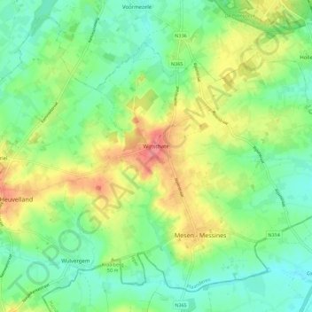
Name: Wijtschate topographic map, elevation, terrain.
Average elevation: 37 m
Minimum elevation: 12 m
Maximum elevation: 84 m
Other topographic maps
Click on a map to view its topography, its elevation and its terrain.
Westouter
België > Vlaanderen > Heuvelland > Westouter
Westouter, Heuvelland, West-Vlaanderen, Vlaanderen, 8954, België
Average elevation: 64 m
Kemmel
België > Vlaanderen > Heuvelland > Kemmel
Kemmel, Heuvelland, West-Vlaanderen, Vlaanderen, 8956, België
Average elevation: 55 m