
City of Ekurhuleni Metropolitan Municipality topographic map
Interactive map
Click on the map to display elevation.
City of Ekurhuleni Metropolitan Municipality
Ekurhuleni lies on the highveld plateau at about 1600 metres in altitude above sea level (asl). The highest elevation is at the Gillooly's Ridge – Bill Stewart Side – Fisher's Hill at 1772 metres asl. The lowest point is at 1552 metres asl. The city is rich in wetlands, pans, streams and rivers. The city is highly urbanised; however, the north especially has high-potential agricultural land.
About this map
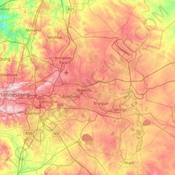
Name: City of Ekurhuleni Metropolitan Municipality topographic map, elevation, terrain.
Average elevation: 1,588 m
Minimum elevation: 1,360 m
Maximum elevation: 1,808 m
Other topographic maps
Click on a map to view its topography, its elevation and its terrain.
Johannesburg
South Africa > Gauteng > City of Johannesburg Metropolitan Municipality
Johannesburg is located in the eastern plateau area of South Africa known as the Highveld, at an elevation of 1,753 metres (5,751 ft). The former Central Business District is located on the southern side of the prominent ridge called the Witwatersrand (English: White Water's Ridge) and the terrain falls to the…
Average elevation: 1,615 m
City of Johannesburg Metropolitan Municipality
South Africa > Gauteng > City of Johannesburg Metropolitan Municipality
Average elevation: 1,615 m