
Daïra El Kantara topographic map
Interactive map
Click on the map to display elevation.
About this map
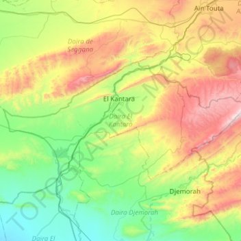
Name: Daïra El Kantara topographic map, elevation, terrain.
Location: Daïra El Kantara, Biskra, Algérie (35.08795 5.47100 35.28565 5.96611)
Average elevation: 706 m
Minimum elevation: 203 m
Maximum elevation: 1,758 m
Other topographic maps
Click on a map to view its topography, its elevation and its terrain.
M'Chouneche
Algérie > Biskra > Daïra M'Chouneche
M'Chouneche, Daïra M'Chouneche, Biskra, Algérie
Average elevation: 425 m