
Hampton topographic map
Interactive map
Click on the map to display elevation.
About this map
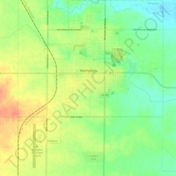
Name: Hampton topographic map, elevation, terrain.
Location: Hampton, Franklin County, Iowa, 50441, United States (42.71614 -93.23198 42.75995 -93.18266)
Average elevation: 346 m
Minimum elevation: 322 m
Maximum elevation: 371 m
Other topographic maps
Click on a map to view its topography, its elevation and its terrain.
Alexander
United States > Iowa > Franklin County
Alexander, Franklin County, Iowa, United States
Average elevation: 380 m
Coulter
United States > Iowa > Franklin County
Coulter, Franklin County, Iowa, 50431, United States
Average elevation: 377 m
Hansell
United States > Iowa > Franklin County
Hansell, Franklin County, Iowa, United States
Average elevation: 315 m
Chapin
United States > Iowa > Franklin County
Chapin, Franklin County, Iowa, 50427, United States
Average elevation: 346 m
Geneva
United States > Iowa > Franklin County
Geneva, Franklin County, Iowa, United States
Average elevation: 331 m
Popejoy
United States > Iowa > Franklin County
Popejoy, Franklin County, Iowa, United States
Average elevation: 353 m
Bradford
United States > Iowa > Franklin County
Bradford, Franklin County, Iowa, 50041, United States
Average elevation: 378 m
Sheffield
United States > Iowa > Franklin County
Sheffield, Franklin County, Iowa, United States
Average elevation: 334 m
Latimer
United States > Iowa > Franklin County
Latimer, Franklin County, Iowa, United States
Average elevation: 377 m